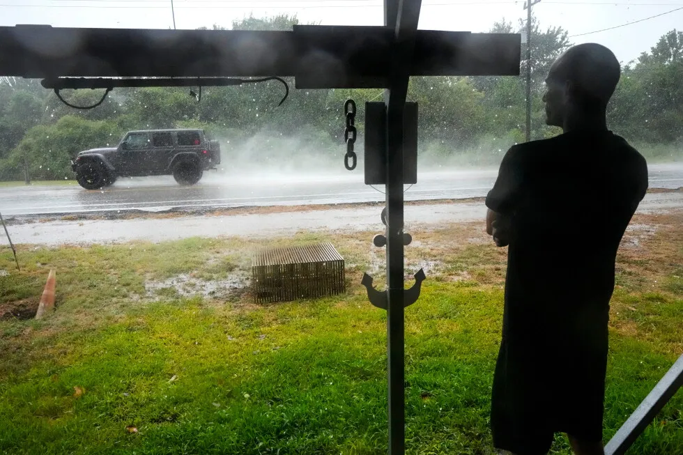
Edouard, now a tropical depression, drenches Texas with flash flooding and downed trees 1 of 5 | Michael Espinoza stands under the awning of his shop, T&M Bait Shop, watching rain from Tropical Storm Edouard come down in High Island, Texas, on Tuesday, Sept. 1, 2026. (Brett Coomer/Houston Chronicle via AP) 2 of 5 | Motorists drive by Texas-department-of-transportation" class="entity-link entity-organization" data-entity-id="198790" data-entity-type="organization">Texas Department of Transportation signs on I-610 as Tropical Storm Edouard approaches in Houston, Tuesday, Sept. 1, 2026. (Elizabeth Conley/Houston Chronicle via AP) 3 of 5 | Vehicle line up to board a Bolivar Ferry ahead of Tropical Storm Edouard in Galveston, Texas, on Tuesday, Sept. 1, 2026. (Brett Coomer/Houston Chronicle via AP) 4 of 5 | A fisherman who goes by the name “Jellybean” casts his line along the ship channel before landfall of Tropical Storm Edouard in Galveston, Texas, on Tuesday, Sept. 1, 2026. (Brett Coomer/Houston Chronicle via AP) 5 of 5 | This satellite image released by NOAA shows three storms Hurricane Lowell, left, Hurricane Karina, center, and Tropical Storm Marie, right, forming in the Pacific Ocean, Wednesday, Sept. 2, 2026. (NOAA via AP) By JAMIE STENGLE and LEKAN OYEKANMI Updated 3:54 PM MESZ, September 2, 2026 Leer en español Add AP News on Google Add AP News as your preferred source to see more of our stories on Google. Share Share Facebook Copy Link copied Print Email X LinkedIn Bluesky Flipboard Pinterest Reddit PORT ARTHUR, Texas (AP) — The former Tropical Storm Edouard weakened into a depression but dumped heavy rain, flooded roads and knocked down trees Wednesday in parts of Texas as it slowly moved north in the state. Schools and municipal offices were closed and residents were told to stay at home. Some areas northwest of Beaumont, where the center of the storm passed Tuesday, received between 10 inches (25 centimeters) and 21 inches (53 centimeters) of rain in a matter of hours, the National Weather Service and emergency officials said. The storm was downgraded Tuesday night, hours after making landfall near the Texas-Louisiana border with maximum sustained winds of 60 mph (95 kph), according to the National Hurricane Center. The system was losing strength as it pushed inland but was still producing heavy rains and some flooding Wednesday. It was expected to break up by Wednesday night. Meanwhile, a burst of tropical weather continued in the Pacific Ocean, where two hurricanes and a tropical storm that was likely to develop into one were churning in open waters Wednesday. Edouard makes landfall along Texas-Louisiana line and floods some roads As the center of Edouard passed over Beaumont, Texas, about 80 miles (130 kilometers) northeast of Houston, it left a path of downed trees blocking roads, traffic signals that weren’t working and flooded underpasses, Beaumont police said in a post on social media. Some drivers were stranded in floodwaters and needed help. Edouard weakens into a tropical depression after landfall but still dumping rain into Texas 2 MIN READ 35 Tropical Storm Edouard forms near Texas and Louisiana while a storm moves toward Hawaii 2 MIN READ Forecasters warn a Pacific system could soak Hawaii as Tropical Storm Cristobal fades 2 MIN READ One weather station in Port Arthur, Texas, recorded a 90 mph (145 kph) wind gust Tuesday. The storm moved north early Wednesday, prompting flood warnings. “This is a particularly dangerous situation. Seek higher ground now!” the weather service said in a post affecting rural communities in parts of Hardin and Tyler counties in southeast Texas. The post said the expected rainfall rate was an inch (2.5 centimeters) to 5 inches (13 centimeters) in an hour Wednesday, in addition to what had already fallen. About 75,000 utility customers across at least eight counties were without electricity as of Wednesday morning, according to poweroutage.com. 2 hurricanes and a tropical storm are in the Pacific Ocean Tropical Storm Marie was well offshore of southwest Mexico in the Pacific and was expected to become a hurricane Wednesday, the Miami-based hurricane center said. Swells generated by the storm were expected to affect parts of the coast in southwestern Mexico and the Baja California peninsula over the next few days. They will likely spread to southern California over the weekend, the center said. “These swells are likely to cause life-threatening surf and rip current conditions,” it said. Forecasters said Hurricane Lowell in the Pacific, a Category 4 storm, was expected to remain several hundred miles away from Hawaii for the next several days at least, but swells from the hurricane were likely to impact parts of the islands beginning Wednesday. Lowell was expected to remain a powerful storm through Friday. Elsewhere in the Pacific, Karina has strengthened into a powerful Category 4 storm. Some additional strengthening was expected Wednesday, but forecasters said it should weaken over the next few days. Stengle reported from Dallas. Associated Press journalists Kathy McCormack in Concord, New Hampshire, Dave Collins in Hartford, Connecticut, Julie Walker in New York and Hallie Golden in Seattle contributed to this report.
SRCAssociated Press (AP)
LANGEN
LEANCenter
WORDS832
ENT12
WED · 2026-09-02 · 14:23 GMTBRIEF NSR-2026-0902-108518
NSR-2026-0902-108518News Report·EN·Human Interest
Edouard, now a tropical depression, drenches Texas with flash flooding and downed trees
Former Tropical Storm Edouard weakened into a tropical depression but caused significant flooding and downed trees across parts of Texas on Wednesday. The storm made landfall near the Texas-Louisiana border Tuesday with 60 mph winds, and by Wednesday, some areas northwest of Beaumont had received up to 21 inches of rain.
Associated Press (AP)Filed 2026-09-02 · 14:23 GMTLean · CenterRead · 4 min
Associated Press (AP)FIG 01
Reading time
4min
Word count
832words
Sources cited
4cited
Entities identified
12entities
Quality score
100%
§ 01
Briefing Summary
AI-generatedNEWSAR · AI
Former Tropical Storm Edouard weakened into a tropical depression but caused significant flooding and downed trees across parts of Texas on Wednesday. The storm made landfall near the Texas-Louisiana border Tuesday with 60 mph winds, and by Wednesday, some areas northwest of Beaumont had received up to 21 inches of rain. Schools and municipal offices closed, and residents were advised to stay home. Beaumont experienced downed trees, non-functioning traffic signals, and flooded underpasses, with some drivers requiring rescue. Approximately 75,000 utility customers lost power across at least eight counties. Meanwhile, two hurricanes and a tropical storm were active in the Pacific Ocean.
Confidence 0.90Sources 4Claims 5Entities 12
§ 02
Article analysis
Model · rule-basedFraming
Human Interest
Environmental
Tone
Measured
AI-assessed
CalmNeutralAlarmist
Factuality
0.90 / 1.00
Factual
LowHigh
Sources cited
4
Well sourced
FewMany
§ 03
Key claims
5 extracted01
Downed trees blocked roads, traffic signals were not working, and underpasses were flooded in Beaumont.
factualBeaumont police
Confidence
1.00
02
The storm made landfall near the Texas-Louisiana border with maximum sustained winds of 60 mph.
statisticNational Hurricane Center
Confidence
1.00
03
Some areas northwest of Beaumont received between 10 and 21 inches of rain in a matter of hours.
statisticNational Weather Service and emergency officials
Confidence
1.00
04
Tropical Storm Edouard weakened into a depression but dumped heavy rain, flooded roads, and knocked down trees in parts of Texas.
factual
Confidence
1.00
05
Two hurricanes and a tropical storm were churning in the Pacific Ocean.
factual
Confidence
0.90
§ 04
Full report
4 min read · 832 words§ 05
Entities
12 identifiedKey playerOppositionContextPositiveNeutralNegative
Organizations3
Locations7
§ 06
Keywords & salience
10 termsflash flooding
1.00
tropical depression
1.00
texas
0.90
downed trees
0.80
heavy rain
0.80
tropical storm edouard
0.70
landfall
0.60
national weather service
0.50
pacific ocean
0.40
tropical weather
0.40
§ 07
Topic connections
Interactive graph Network visualization showing 6 related topics
View Full Graph Person Organization Location Event|Click node to navigate|Edge numbers = shared articles