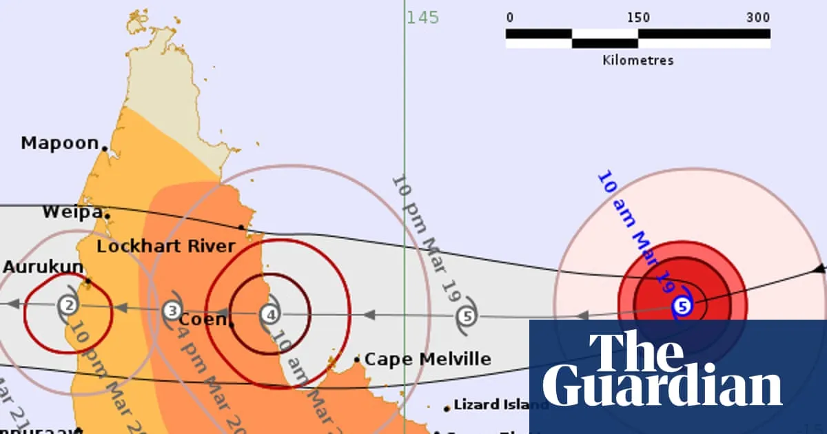
Massive storm tracking a path to Queensland coast, which intensified offshore Thursday morning to category five, fuelled by warm waters in Coral Sea Follow our Australia news live blog for latest updates Get our breaking news email , free app or daily news podcast Severe Tropical Cyclone Narelle is expected to make landfall in far north Queensland on Friday morning as a monster category four storm, bringing destructive wind gusts in excess of 225km/h, according to the Bureau of Meteorology. The severe cyclone rapidly intensified over the past 48 hours and on Thursday morning had built to a category five storm that was barrelling west, sitting about 500km east of the small town of Coen. Continue reading...
SRCThe Guardian - World News
LANGEN
LEANCenter-Left
WORDS117
ENT5
THU · 2026-03-19 · 01:56 GMTBRIEF NSR-2026-0319-25883
NSR-2026-0319-25883News Report·EN·Environmental
Tropical Cyclone Narelle to make landfall in far north Qld on Friday as category four storm, bringing 200km/h winds
Severe Tropical Cyclone Narelle is forecast to make landfall in far north Queensland on Friday morning as a category four storm. The Bureau of Meteorology predicts destructive wind gusts exceeding 225km/h.
Graham ReadfearnThe Guardian - World NewsFiled 2026-03-19 · 01:56 GMTLean · Center-LeftRead · 1 min
The Guardian - World NewsFIG 01
Reading time
1min
Word count
117words
Sources cited
1cited
Entities identified
5entities
Quality score
100%
§ 01
Briefing Summary
AI-generatedNEWSAR · AI
Severe Tropical Cyclone Narelle is forecast to make landfall in far north Queensland on Friday morning as a category four storm. The Bureau of Meteorology predicts destructive wind gusts exceeding 225km/h. Narelle rapidly intensified over the past 48 hours, reaching category five status on Thursday morning while located approximately 500km east of Coen. The cyclone's intensification is attributed to warm waters in the Coral Sea. Residents in the affected region are urged to prepare for the impact of the severe weather event.
Confidence 0.85Sources 1Claims 4Entities 5
§ 02
Article analysis
Model · rule-basedFraming
Environmental
Public Health
Tone
Mixed Tone
AI-assessed
CalmNeutralAlarmist
Factuality
0.80 / 1.00
Factual
LowHigh
Sources cited
1
Limited
FewMany
§ 03
Key claims
4 extracted01
On Thursday morning the storm was sitting about 500km east of the small town of Coen.
factualnull
Confidence
1.00
02
The severe cyclone rapidly intensified over the past 48 hours.
factualnull
Confidence
1.00
03
The cyclone is expected to bring destructive wind gusts in excess of 225km/h.
predictionBureau of Meteorology
Confidence
0.90
04
Severe Tropical Cyclone Narelle is expected to make landfall in far north Queensland on Friday morning.
predictionnull
Confidence
0.90
§ 04
Full report
1 min read · 117 words§ 05
Entities
5 identifiedKey playerOppositionContextPositiveNeutralNegative
Organizations1
§ 06
Keywords & salience
9 termstropical cyclone
1.00
severe cyclone
0.90
landfall
0.80
category four storm
0.80
queensland
0.70
wind gusts
0.70
bureau of meteorology
0.60
coral sea
0.50
category five
0.50
§ 07
Topic connections
Interactive graph No topic relationship data available yet. This graph will appear once topic relationships have been computed.