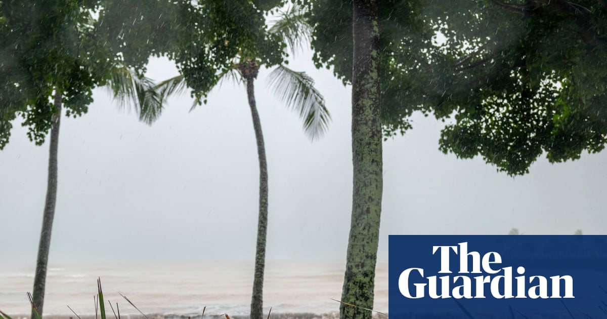
Queenslanders are bracing for floods as repairs are under way after a tropical cyclone battered the far north coast.After days of intense buildup, ex-Tropical Cyclone Koji ran out of power as it crossed the Queensland coast and was downgraded to a tropical low on Sunday.Cyclone warnings were cancelled, but residents in the far north still faced the threat of major flooding as heavy rain continued to pummel the region.Thousands were without power as authorities worked to restore electricity to affected areas.Hamilton Island recorded winds of 113km/h when the weather system made landfall early on Monday, but concerns about wild winds have abated with the main focus now on the impact of heavy rainfall.The premier, David Crisafulli, was confident Queenslanders could handle whatever came their way.“There is the risk in that next 24 to 48 hours of some really significant rainfall in patches,” Crisafulli told Nine’s Today on Monday from Bowen.“If people do the right thing and have those preparations we’ll continue to get through this unscathed.”He will chair the state disaster meeting from Proserpine later on Monday.Warnings were issued for heavy rain along the central Queensland coast, with falls expected to continue into Monday.Some areas were forecast to see isolated totals of up to 340mm in 24 hours across saturated catchments, according to the Bureau of Meteorology.Flood watches remained in place for the Channel Country after the monsoon earlier devastated the state’s northwest, isolating towns and properties.The mammoth clean-up has barely begun, with conservative estimates of more than 45,000 livestock missing or dead.“We will continue to watch and see the impact that the system could have – the last thing we want to see is more rainfall in areas that have copped more than a year’s supply in less than a week,” Crisafulli said.Fodder drops continued, and authorities were stockpiling antibiotics and veterinary supplies to treat surviving stock and combat infection.“The economic impact for western Queensland, because of how important agriculture is to underpin those communities, will be large,” Crisafulli said.“We’re doing everything we can to spare as many cattle as possible and help those primary producers.”Flood warnings were in place on Monday morning for catchments including Herbert, Upper Burdekin, Lower Burdekin, Haughton, Ross, Bohle, Don, Proserpine, Pioneer, Lower Flinders, Norman, Gilbert, Georgina and Eyre, Diamantina and Thomson on.
SRCThe Guardian - World News
LANGEN
LEANCenter-Left
WORDS379
ENT4
SUN · 2026-01-11 · 23:43 GMTBRIEF NSR-2026-0112-6950
NSR-2026-0112-6950News Report·EN·Environmental
Queensland weather: state braces for heavy rain and floods after ex-Tropical Cyclone Koji batters far north
After battering Queensland's far north coast, ex-Tropical Cyclone Koji was downgraded to a tropical low, but the state is now bracing for potential major flooding due to heavy rainfall. While cyclone warnings have been cancelled, areas along the central Queensland coast are expected to receive significant rainfall, with some areas potentially seeing up to 340mm in 24 hours.
Australian Associated PressThe Guardian - World NewsFiled 2026-01-11 · 23:43 GMTLean · Center-LeftRead · 2 min
The Guardian - World NewsFIG 01
Reading time
2min
Word count
379words
Sources cited
2cited
Entities identified
4entities
Quality score
100%
§ 01
Briefing Summary
AI-generatedNEWSAR · AI
After battering Queensland's far north coast, ex-Tropical Cyclone Koji was downgraded to a tropical low, but the state is now bracing for potential major flooding due to heavy rainfall. While cyclone warnings have been cancelled, areas along the central Queensland coast are expected to receive significant rainfall, with some areas potentially seeing up to 340mm in 24 hours. Thousands remain without power as authorities work to restore electricity. Flood watches are also in place for the Channel Country, which was previously devastated by monsoon rains, impacting livestock and agriculture. The Premier is chairing a state disaster meeting and authorities are focusing on fodder drops and veterinary supplies to assist affected communities and livestock. Flood warnings are in place for numerous catchments across Queensland.
Confidence 0.90Sources 2Claims 5Entities 4
§ 02
Article analysis
Model · rule-basedFraming
Environmental
Economic Impact
Tone
Measured
AI-assessed
CalmNeutralAlarmist
Factuality
0.80 / 1.00
Factual
LowHigh
Sources cited
2
Limited
FewMany
§ 03
Key claims
5 extracted01
Some areas were forecast to see isolated totals of up to 340mm in 24 hours.
factualBureau of Meteorology
Confidence
1.00
02
Hamilton Island recorded winds of 113km/h when the weather system made landfall early on Monday.
factualnull
Confidence
1.00
03
Ex-Tropical Cyclone Koji was downgraded to a tropical low on Sunday.
factualnull
Confidence
1.00
04
Conservative estimates of more than 45,000 livestock missing or dead.
statisticnull
Confidence
0.90
05
There is the risk in that next 24 to 48 hours of some really significant rainfall in patches.
predictionDavid Crisafulli
Confidence
0.80
§ 04
Full report
2 min read · 379 words§ 05
Entities
4 identifiedKey playerOppositionContextPositiveNeutralNegative
Organizations1
§ 06
Keywords & salience
10 termsfloods
0.90
heavy rain
0.90
queensland
0.80
tropical cyclone
0.80
flood warnings
0.70
livestock
0.60
weather system
0.60
power outages
0.60
state disaster
0.50
agriculture
0.50
§ 07
Topic connections
Interactive graph Network visualization showing 29 related topics
View Full Graph Person Organization Location Event|Click node to navigate|Edge numbers = shared articles