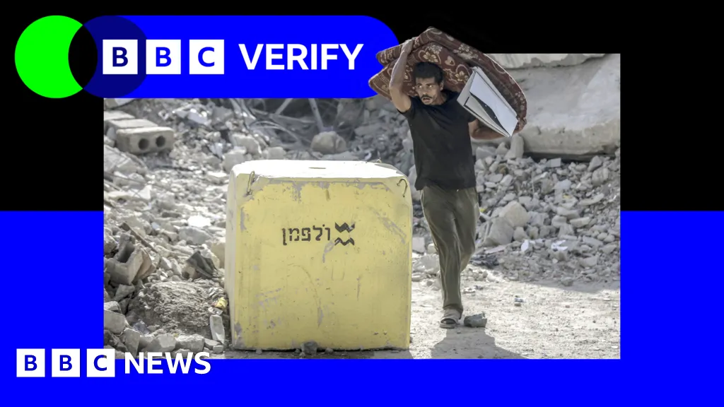
7 hours agoBenedict Garman,Emma PengellyandMatt Murphy,BBC Verify BBCIsrael has moved the blocks which are supposed to mark its post-ceasefire line of control deeper into Gaza in several places, sowing confusion among Palestinians.Satellite images reviewed by BBC Verify show that in at least three areas Israel placed blocks, before returning later and moving the positions further into the Strip.Under the terms of the US-brokered deal with Hamas, Israel agreed to withdraw troops beyond a line marked in yellow on Israeli military maps, which it has illustrated on the ground with concrete yellow blocks.Defence Minister Israel-katz" class="entity-link entity-person" data-entity-id="4249" data-entity-type="person">Israel Katz warned in October that anyone crossing the Yellow Line would be "met with fire".Since these comments were made, there have been a series of deadly incidents around the line.In Beit Lahia, Jabalia and al-Tuffah, the Israel Defense Forces (IDF) placed blocks and later returned to move them deeper inside Gaza. In total, 16 positions were moved.In the al-Tuffah neighbourhood of Gaza City, satellite images show that IDF troops moved at least seven already placed blocks between 27 November and 25 December. The position of the markers were moved on average 295m (968ft) deeper inside the Strip.As well as the blocks that have been moved, BBC Verify mapped 205 other markers. More than half of those have been placed significantly deeper inside the Strip than the line marked on maps.An IDF spokesperson said it rejected "all claims that the Yellow Line has been moved or its crossing by IDF troops"."The IDF is operating to visually mark the Yellow Line in accordance with the conditions on the ground and the ongoing operational situational assessment," they added.Analysis of satellite images up to 11 January suggests some sections of the Yellow Line - which the head of Israel's military described as a "new border line" - also remain unmarked on the ground more than three months since the ceasefire began.The latest satellite images reviewed by BBC Verify show that blocks have not been placed along roughly 10km (six miles) of territory - leaving some people in Gaza struggling to know where the beginning of what the IDF calls a "dangerous combat zone" is.Last month, one 23-year-old man near Khan Younis - whom the BBC is not naming for his own safety - said Israeli troops suddenly moved blocks near him beyond the mapped line, leaving him "trapped"."We are now living inside the Yellow Line, [but] behind the yellow blocks, with no idea what our fate will be," he said. "The atmosphere at night is terrifying. We hear shells exploding, soldiers advancing, gunfire, and drones buzzing overhead without pause. We are also being shot at directly."Prof Andreas Krieg, a Middle East security expert from King's College London, has called the movement of the blocks a "tool for territorial engineering"."By keeping the legal line on the map and the physical blocks hundreds of metres apart, Israel preserves the ability to shift where Gazans may live, move and farm without ever formally announcing a change of border," he said.But Efraim Inbar - president of the Jerusalem Institute for Strategy and Security - suggested that the mapped line may not account for natural barriers to the markers and that IDF engineers may be putting the blocks where they "find it easier to place".Series of deadly incidents around the Yellow LineSince Katz's warning in October, troops have shot at people crossing the Yellow Line on at least 69 occasions, an analysis of IDF Telegram posts and statements to the BBC showed.On 19 December, the IDF conducted a strike on a school sheltering displaced people in the al-Tuffah neighbourhood of Gaza City - some 330m inside the Palestinian side of the line, according to the IDF maps - but just metres from a yellow block that was moved there. Eyewitnesses said it happened while a wedding was taking place right by the school building. Five people, including children, were killed in the blast, Gaza's Hamas-run Civil Defence agency said.An IDF statement relating to that day said they fired at "suspicious individuals" west of the Yellow Line, adding that the incident remained under review and that it "regrets any harm to uninvolved individuals".In another deadly incident, 17-year-old Zaher Nasser Shamiya was killed near yellow blocks in Jabalia camp in northern Gaza. His father said IDF troops fired at him before running him over with a tank on 10 December."The tank turned his body into pieces… it came into the safe area [west of the Yellow Line] and ran over him," he said. BBC Verify has approached the IDF for comment on the incident.And in November, local media reported that two children - aged eight and 10 or 11 - were killed by Israeli forces. Their uncle said that the pair had been gathering firewood for their disabled father when they were killed.Addressing the deaths, an IDF statement said it had eliminated two suspects who crossed the Yellow Line, conducted suspicious activities on the ground, and approached IDF troops. It did not offer details on how the pair were identified as suspects.An IDF spokesperson accused Hamas fighters of firing on troops six times "beyond the Yellow Line" over the past week, in a statement to BBC Verify.Demolitions and fortificationWhile Israel agreed to withdraw its forces behind the Yellow Line under October's ceasefire deal, videos and satellite images seen by BBC Verify have repeatedly shown IDF vehicles operating beyond the mapped Yellow Line.In verified clips, armoured personnel carriers and bulldozers were seen 400m past the mapped Yellow Line at the Bani Suhaila roundabout in Khan Younis, while a satellite image taken on 25 December appeared to show a tank, excavator and other IDF vehicles positioned about 260m beyond the Yellow Line in Beit Lahia.In some cases, the movements of blocks were followed by demolitions of nearby buildings by the IDF.In the eastern part of Gaza City, satellite images show that hundreds of buildings were levelled up to and even beyond the first position of the blocks, then the markers were moved and there was further destructionIn the nearby area of Jabalia, Israeli troops demolished a series of school buildings that were around 150m inside the mapped line.In some instances where IDF demolitions have occurred, the debris has effectively hidden the markers from Palestinians on the ground.An IDF spokesperson said that troops were dismantling Hamas' tunnel network that it said runs under buildings on both sides of the Yellow Line, adding that the tunnels' destruction "may cause the collapse of buildings on both sides of the line". On Wednesday, the US said the second phase of the ceasefire deal is due to begin, under which Israel is expected to withdraw from additional parts of the Strip. But there was no mention of a timeline for the withdrawal, which is linked to the "demilitarisation" of Hamas under October's ceasefire deal.In parts of the Strip, the markers have been placed shortly before work began on the construction of temporary Israeli fortifications such as roadblocks and defensive barriers beyond the mapped Yellow Line.Krieg told BBC Verify that the movement of the blocks would eventually allow Israel to turn parts of Gaza into a "sterilised belt"."In practice, that means the status of land is less about what the ceasefire map says and more about where concrete blocks sit on a given day," he said.
SRCBBC News - World
LANGEN
LEANCenter
WORDS1 211
ENT11
FRI · 2026-01-16 · 00:02 GMTBRIEF NSR-2026-0116-7814
NSR-2026-0116-7814News Report·EN·Conflict
Israel moves Yellow Line deeper into Gaza, satellite images show
Satellite images analyzed by BBC Verify show Israel has moved concrete blocks marking its post-ceasefire line of control, known as the Yellow Line, deeper into Gaza in multiple locations. The IDF initially placed blocks in areas like Beit Lahia, Jabalia, and al-Tuffah, then repositioned them further into the Strip, with some markers moved nearly 300 meters.
BBC News - WorldFiled 2026-01-16 · 00:02 GMTLean · CenterRead · 5 min
BBC News - WorldFIG 01
Reading time
5min
Word count
1 211words
Sources cited
4cited
Entities identified
11entities
Quality score
100%
§ 01
Briefing Summary
AI-generatedNEWSAR · AI
Satellite images analyzed by BBC Verify show Israel has moved concrete blocks marking its post-ceasefire line of control, known as the Yellow Line, deeper into Gaza in multiple locations. The IDF initially placed blocks in areas like Beit Lahia, Jabalia, and al-Tuffah, then repositioned them further into the Strip, with some markers moved nearly 300 meters. While the IDF claims the line is being marked according to conditions on the ground, over half of the mapped markers are placed significantly deeper than indicated on military maps. Approximately 10 kilometers of the Yellow Line remain unmarked, causing confusion among Palestinians about the boundaries of the "dangerous combat zone." The US-brokered deal with Hamas stipulated Israel's withdrawal beyond this Yellow Line.
Confidence 0.90Sources 4Claims 5Entities 11
§ 02
Article analysis
Model · rule-basedFraming
Conflict
Political Strategy
Tone
Measured
AI-assessed
CalmNeutralAlarmist
Factuality
0.80 / 1.00
Factual
LowHigh
Sources cited
4
Well sourced
FewMany
§ 03
Key claims
5 extracted01
The IDF is operating to visually mark the Yellow Line in accordance with the conditions on the ground.
quoteIDF spokesperson
Confidence
1.00
02
The position of the markers were moved on average 295m (968ft) deeper inside the Strip.
statisticBBC Verify
Confidence
1.00
03
In the al-Tuffah neighbourhood of Gaza City, IDF troops moved at least seven already placed blocks between 27 November and 25 December.
factualBBC Verify
Confidence
1.00
04
Israel has moved the blocks which are supposed to mark its post-ceasefire line of control deeper into Gaza in several places.
factualBBC Verify
Confidence
1.00
05
By keeping the legal line on the map and the physical blocks hundreds of metres apart, Israel preserves the ability to shift where Gazans may live.
quoteProf Andreas Krieg
Confidence
0.80
§ 04
Full report
5 min read · 1 211 words§ 05
Entities
11 identifiedKey playerOppositionContextPositiveNeutralNegative
§ 06
Keywords & salience
9 termsyellow line
1.00
gaza
0.90
israel
0.80
idf
0.70
line of control
0.60
satellite images
0.60
concrete blocks
0.50
ceasefire
0.50
military maps
0.40
§ 07
Topic connections
Interactive graph Network visualization showing 51 related topics
View Full Graph Person Organization Location Event|Click node to navigate|Edge numbers = shared articles