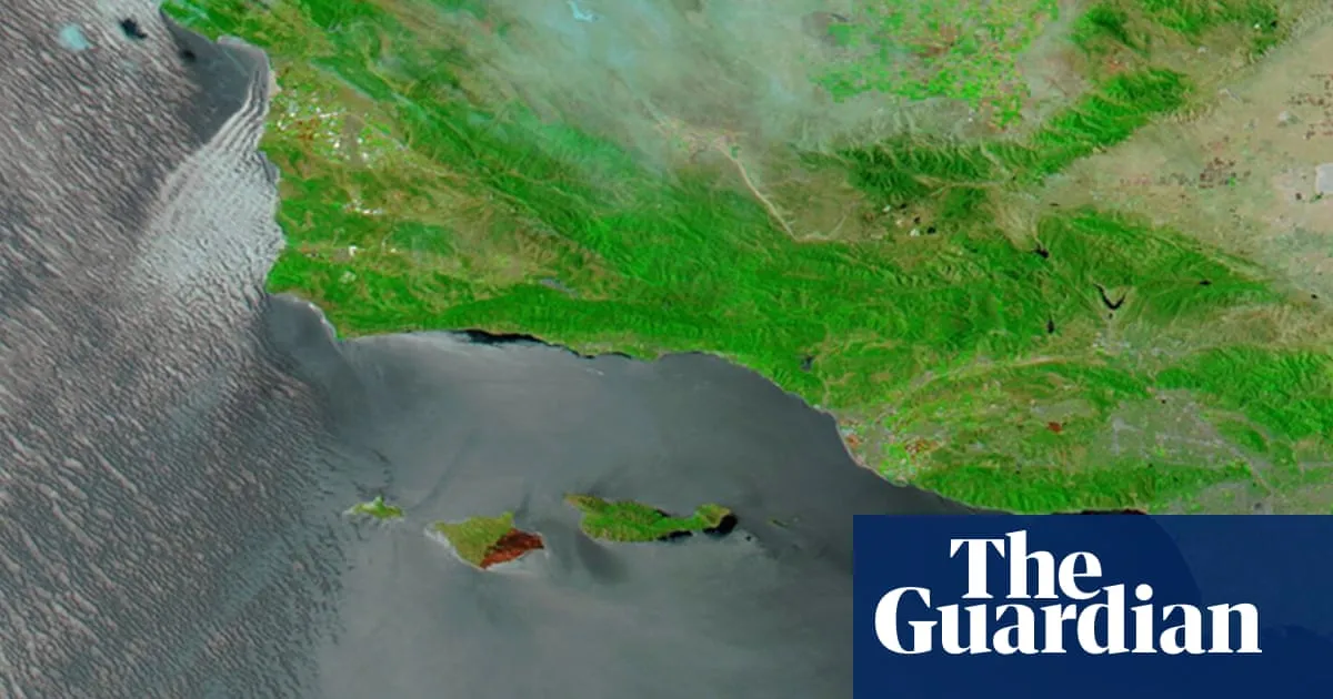
A false-color image of burn scars on 20 May in southern California, acquired by the Moderate Resolution Imaging Spectroradiometer (Modis) on NASA’s Aqua satellite. Photograph: Modis/NASA View image in fullscreen A false-color image of burn scars on 20 May in southern California, acquired by the Moderate Resolution Imaging Spectroradiometer (Modis) on NASA’s Aqua satellite. Photograph: Modis/NASA NASA images show wildfire damage to island dubbed ‘Galapagos of California’ The satellite visuals reveal vast burn scars after blaze tore through rare ecosystems on Santa Rosa Island Images from a NASA satellite showcased the devastating scars left behind by a wildfire that consumed roughly a third of Santa Rosa Island, one of the five islands that make up Channel Islands national park off the southern California coast. Taken on 20 May, the Moderate Resolution Imaging Spectroradiometer (Modis) took the false-color image of the burn area, showing swaths of blackened land. While the fire is mostly contained, the images drive home the potential lasting impact on the unique ecosystems across the rugged and remote island. Home to scores of rare and threatened species, Santa Rosa Island provides habitat to some plants and animals found nowhere else on earth. The fire that scorched more than 18,300 acres (7,400 hectares) is believed to be the largest recorded on the island, officials said. The landscapes that evolved separately from California’s mainland are not considered fire-adapted ecosystems, and blazes of this magnitude and size are uncommon here. While the cause of the fire is still under investigation, according to National Park Service officials, flames were spotted after a sailor crashed his boat onto Santa Rosa Island’s rocky shores and fired flares to seek help. Images shared by the coast guard showed that “SOS” was carved into the charred ground by the 67-year-old man before he was rescued by helicopter. Fire crews who were boated in to battle the blaze faced extreme fire behavior fueled by strong winds, while the thick coastal marine layer and challenging terrain inhibited aerial support and caused communication and access issues, according to official updates from Cal Fire. The delicate habitats and archeological sites threatened by the flames also had to be protected. Resource advisers – teams of restoration biologists, archeologists and cultural experts – were on site during the firefight to limit disturbances caused by strategies to contain the blaze, including deep gouges into the soil and vegetation made by bulldozers. “As soon as it’s safe, Burned Area Emergency Response (BAER) specialists will arrive on the island to begin assessing soil stability, hydrological changes, infrastructure damage, and threats to cultural and natural resources,” Ana Cholo, a spokesperson, said in an emailed statement. “The post-fire landscape is fragile, and one of the goals the BAER team has is to determine how to protect conditions and reduce further damage during the sensitive recovery period, and also what that recovery may look like.” The archipelago that makes up Channel Islands national park is often referred to as the “Galapagos of California”, due to the abundant and diverse life that calls its sweeping hillsides and underwater kelp forests home. Many of the species supported here are endangered or threatened. Roughly 46 plants and animals are endemic to Santa Rosa Island, according to the NPS, including some of the most sensitive species found in the region. Seven federally listed plant species can be found here, “all confined to small, fragile habitats that are extremely vulnerable to disturbance, erosion, and post‑fire impacts”, the non-profit Channel Islands Park Foundation said in an online post about the blaze. Native animals include the island fox and deer mice, which evolved into separate subspecies on each island. The island’s Torrey pines that grow on sandstone bluffs along its north-east corner suffered some damage, according to initial assessments, but remain “largely intact”. The trees, which are considered among the rarest pines on earth, grow only on Santa Rosa Island and in a small stand in San Diego. “Santa Rosa Island is a sanctuary of rare species, ancient culture, and rugged beauty shaped by wind, sea, and time,” Cholo said. “These are ancestral Chumash lands, home to cultural sites that span more than 13,000 years. The island holds a unique place in California’s history, and we recognize how meaningful it is to all who care about it.” Explore more on these topics US news NASA Wildfires California California wildfires West Coast Space news Share Reuse this content
SRCThe Guardian - World News
LANGEN
LEANCenter-Left
WORDS732
ENT9
WED · 2026-05-27 · 20:28 GMTBRIEF NSR-2026-0527-79739
NSR-2026-0527-79739News Report·EN·Environmental
Nasa images show wildfire damage to island dubbed ‘Galapagos of California’
NASA satellite images reveal significant burn scars on Santa Rosa Island, a part of Channel Islands National Park, following a wildfire that consumed approximately one-third of the island. The blaze, believed to be the largest recorded on the island, impacted rare and endemic ecosystems, home to numerous threatened species.
Gabrielle CanonThe Guardian - World NewsFiled 2026-05-27 · 20:28 GMTLean · Center-LeftRead · 3 min
The Guardian - World NewsFIG 01
Reading time
3min
Word count
732words
Sources cited
3cited
Entities identified
9entities
Quality score
100%
§ 01
Briefing Summary
AI-generatedNEWSAR · AI
NASA satellite images reveal significant burn scars on Santa Rosa Island, a part of Channel Islands National Park, following a wildfire that consumed approximately one-third of the island. The blaze, believed to be the largest recorded on the island, impacted rare and endemic ecosystems, home to numerous threatened species. The fire, whose cause is under investigation, was reportedly sparked after a sailor crashed his boat and fired flares for rescue. Fire crews faced challenges due to strong winds, terrain, and communication issues. Burned Area Emergency Response specialists will assess the damage to soil, hydrology, infrastructure, and cultural resources to guide the island's recovery.
Confidence 0.90Sources 3Claims 5Entities 9
§ 02
Article analysis
Model · rule-basedFraming
Environmental
Human Interest
Tone
Mixed Tone
AI-assessed
CalmNeutralAlarmist
Factuality
0.80 / 1.00
Factual
LowHigh
Sources cited
3
Well sourced
FewMany
§ 03
Key claims
5 extracted01
The landscapes on Santa Rosa Island are not considered fire-adapted ecosystems, making large blazes uncommon.
factual
Confidence
1.00
02
Santa Rosa Island is home to scores of rare and threatened species, including plants and animals found nowhere else on Earth.
factual
Confidence
1.00
03
The wildfire consumed roughly a third of Santa Rosa Island, scorching more than 18,300 acres (7,400 hectares).
statisticofficials
Confidence
1.00
04
Nasa images show wildfire damage to Santa Rosa Island, revealing vast burn scars after a blaze tore through rare ecosystems.
factual
Confidence
1.00
05
The fire is believed to have started after a sailor crashed his boat and fired flares to seek help.
factualNational Park Service officials
Confidence
0.90
§ 04
Full report
3 min read · 732 words§ 05
Entities
9 identifiedKey playerOppositionContextPositiveNeutralNegative
Organizations3
Locations3
§ 06
Keywords & salience
8 termssanta rosa island
1.00
wildfire damage
1.00
nasa images
0.90
rare ecosystems
0.80
channel islands
0.70
burn scars
0.60
satellite visuals
0.50
fire-adapted ecosystems
0.40
§ 07
Topic connections
Interactive graph Network visualization showing 45 related topics
View Full Graph Person Organization Location Event|Click node to navigate|Edge numbers = shared articles