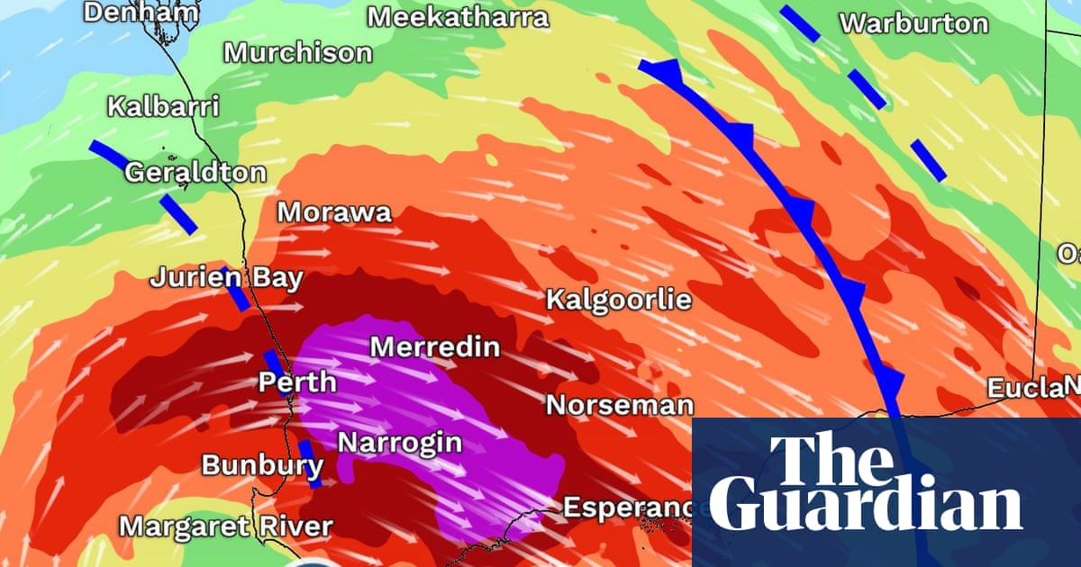
Residents across WA’s south-west were told to prepare for destructive wind gusts from Saturday evening, along with possible thunderstorms, heavy downpours, Flash Flooding, damaging surf and a risk of tornadoes. Photograph: Bureau of Meteorology via Facebook View image in fullscreen Residents across WA’s south-west were told to prepare for destructive wind gusts from Saturday evening, along with possible thunderstorms, heavy downpours, Flash Flooding, damaging surf and a risk of tornadoes. Photograph: Bureau of Meteorology via Facebook ‘Significant’ storm to hammer millions in WA and bring icy weather to NSW, Victoria and SA Bureau of Meteorology says WA residents should brace for wind gusts higher than 125km/h – the strength of category two cyclones Get our breaking news email, free app or daily news podcast A major storm system bearing down on millions of Western Australians on Saturday is bringing cyclone-strength winds, and is set to deliver a “wintry blast” to the east of the country early next week. Residents across WA’s populated south-west were warned to tie down loose items and prepare for destructive wind gusts that could exceed 125km/h from Saturday evening. The Bureau of Meteorology warned that along with the damaging winds could come thunderstorms, heavy downpours, Flash Flooding, damaging surf and a risk of tornadoes. Wind gusts higher than 125km/h are typically associated with category two cyclones. While early winter storm systems are not new for the region, Daniel Hayes at the bureau warned “this one looks quite significant”. A deep low pressure system – where air is rising – was moving towards the WA coastline on Saturday and was dragging tropical moisture with it to bring heavy downpours and strong winds. A bureau warning covering the entire south-west of WA was in place on Saturday morning. Residents were told to prepare properties and tie down any loose items. Six-hourly rainfall totals of up to 60mm were predicted in central west areas of the region from late Saturday until early on Sunday. The entire south-west coastline was also under a warning for abnormally high tides and damaging surf. From Sunday morning, low-lying areas could see flooding and residents were warned to stay away from surf and exposed areas. A second round of wind gusts up to 125km/h were expected on Sunday night between Lancelin and Albany, including Perth. Hayes said residents in South Australia and in Alpine areas of Victoria would likely be under further warnings by Sunday as the system moved east. “By Monday we are seeing impacts across to South Australia and later on Monday and Tuesday some of that rain and wind is picking up in parts of Victoria and New South Wales. “Once that front moves through we start to see a pronounced wintry blast. It’s going to feel noticeably cool with these strong winds.” Wind gusts of 50km/h were forecast for Melbourne on Monday evening. Hayes said there could be snow falls in alpine areas early next week. But he said the system’s connection to tropical moisture would break down as it moved east, reducing the amount of rain it could bring. While the conditions would herald the arrival of winter, the bureau’s long-range forecast for winter shows the southern two-thirds of the country will be warmer than average. That forecast also accounts for developments in the tropical Pacific Ocean, where meteorologists are watching for the likely development of an El Niño this winter. Previous El Niños have brought warmer and drier conditions to Australia’s east during spring periods. The phenomenon can push up global temperatures and experts have said the system, when combined with global heating, could see 2027 become the hottest year on record. Explore more on these topics Australia weather Western Australia Perth South Australia Victoria New South Wales news Share Reuse this content
SRCThe Guardian - World News
LANGEN
LEANCenter-Left
WORDS625
ENT12
SAT · 2026-05-30 · 02:49 GMTBRIEF NSR-2026-0530-80342
NSR-2026-0530-80342News Report·EN·Human Interest
‘Significant’ storm to hammer millions in WA and bring icy weather to NSW, Victoria and SA
A significant storm system is set to impact Western Australia with destructive wind gusts exceeding 125km/h from Saturday evening, comparable to category two cyclones. Residents in the south-west are warned of potential thunderstorms, heavy downpours, flash flooding, damaging surf, and a risk of tornadoes.
Graham ReadfearnThe Guardian - World NewsFiled 2026-05-30 · 02:49 GMTLean · Center-LeftRead · 3 min
The Guardian - World NewsFIG 01
Reading time
3min
Word count
625words
Sources cited
1cited
Entities identified
12entities
Quality score
100%
§ 01
Briefing Summary
AI-generatedNEWSAR · AI
A significant storm system is set to impact Western Australia with destructive wind gusts exceeding 125km/h from Saturday evening, comparable to category two cyclones. Residents in the south-west are warned of potential thunderstorms, heavy downpours, flash flooding, damaging surf, and a risk of tornadoes. The Bureau of Meteorology has issued warnings for the entire south-west region, advising residents to secure loose items. As the system moves east, it is expected to bring a "wintry blast" to South Australia, Victoria, and New South Wales early next week, with cooler temperatures and strong winds. Snowfall is possible in alpine areas of Victoria.
Confidence 0.90Sources 1Claims 5Entities 12
§ 02
Article analysis
Model · rule-basedFraming
Human Interest
Environmental
Tone
Mixed Tone
AI-assessed
CalmNeutralAlarmist
Factuality
0.80 / 1.00
Factual
LowHigh
Sources cited
1
Limited
FewMany
§ 03
Key claims
5 extracted01
Destructive wind gusts exceeding 125km/h are expected in WA's south-west from Saturday evening.
predictionBureau of Meteorology
Confidence
0.90
02
The storm system will bring a 'wintry blast' to NSW, Victoria, and SA early next week.
predictionDaniel Hayes (Bureau of Meteorology)
Confidence
0.85
03
Six-hourly rainfall totals of up to 60mm are predicted in central west WA from late Saturday until early Sunday.
predictionBureau of Meteorology
Confidence
0.80
04
Wind gusts of 50km/h are forecast for Melbourne on Monday evening.
predictionBureau of Meteorology
Confidence
0.75
05
There is a risk of tornadoes in WA's south-west.
predictionBureau of Meteorology
Confidence
0.70
§ 04
Full report
3 min read · 625 words§ 05
Entities
12 identifiedKey playerOppositionContextPositiveNeutralNegative
Organizations1
Locations5
Events4
Topics1
§ 06
Keywords & salience
10 termsdestructive wind gusts
1.00
storm system
1.00
icy weather
0.90
flash flooding
0.80
cyclone-strength winds
0.80
heavy downpours
0.70
damaging surf
0.60
risk of tornadoes
0.50
bureau of meteorology
0.50
low pressure system
0.40
§ 07
Topic connections
Interactive graph Network visualization showing 30 related topics
View Full Graph Person Organization Location Event|Click node to navigate|Edge numbers = shared articles