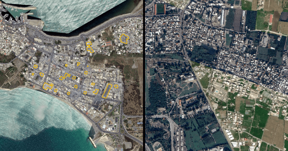
Satellite data shows damage to residential areas, UNESCO World Heritage buffer zones and Palestinian camps in Israeli attacks.Newly evaluated satellite images show widespread destruction across the southern Lebanese coastal city of Tyre, following a relentless wave of Israeli air strikes after systematic forced displacement orders.An analysis of the images by Al Jazeera’s open-source unit, which compared satellite data captured between January 4 and June 4, 2026, reveals a deliberate pattern of land-clearing and demolition. The imagery shows extensive bulldozing and levelling of entirely populated civilian blocks, turning multistorey residential complexes into flattened fields of rubble.Recommended Stories list of 4 itemslist 1 of 4Hundred days of Israel’s latest war on Lebanonlist 2 of 4Israel kills 17 in Lebanon as Trump says US-Iran in ‘final throes’ of deallist 3 of 4Iran attacks Bahrain, Kuwait, Jordan in retaliation for US strikeslist 4 of 4Iran war day 103: US strikes after helicopter shot down, Tehran hits backend of listThe devastation unfolds as Israel has enforced a “Yellow Line” policy, similar to Gaza, establishing a 10km-deep buffer zone along the border. Lebanese residents have been strictly barred from returning to the so-called military zone.Situated just 11km (6.5 miles) from this exclusionary line, the ancient maritime city of Tyre, dating back nearly 5,000 years, has found itself on the front line of the military escalation.The civil defence in southern Lebanon told Al Jazeera on Wednesday that at least six people were killed following the latest Israeli strikes on the town of Tayr Debba in the Tyre district. This comes a day after 20 people were killed and dozens wounded in Israeli attacks in southern Lebanon despite a US-brokered ceasefire being in place.More than 3,600 people have been killed and some 1.2 million have been displaced in the Israeli military offensive since March 2.According to data provided by the Tyre municipality, the military action has taken a heavy toll on the city’s civilian infrastructure:
SRCAl Jazeera
LANGEN
LEANCenter
WORDS317
ENT12
WED · 2026-06-10 · 11:46 GMTBRIEF NSR-2026-0610-83272
NSR-2026-0610-83272News Report·EN·Conflict
Satellite images show Israel’s destruction of historical city of Tyre
Satellite data analyzed by Al Jazeera reveals extensive destruction in the southern Lebanese city of Tyre between January 4 and June 4, 2026, following Israeli air strikes. The imagery shows widespread bulldozing and demolition of residential areas, including multi-story complexes, and damage to UNESCO World Heritage buffer zones and Palestinian camps.
Al Jazeera StaffAl JazeeraFiled 2026-06-10 · 11:46 GMTLean · CenterRead · 2 min
Al JazeeraFIG 01
Reading time
2min
Word count
317words
Sources cited
2cited
Entities identified
12entities
Quality score
100%
§ 01
Briefing Summary
AI-generatedNEWSAR · AI
Satellite data analyzed by Al Jazeera reveals extensive destruction in the southern Lebanese city of Tyre between January 4 and June 4, 2026, following Israeli air strikes. The imagery shows widespread bulldozing and demolition of residential areas, including multi-story complexes, and damage to UNESCO World Heritage buffer zones and Palestinian camps. This destruction occurs as Israel enforces a 10km "Yellow Line" buffer zone along the border, barring residents from returning to the area. The ancient city of Tyre, located near this zone, has been impacted by the military escalation. Recent Israeli strikes in the Tyre district have resulted in casualties, with a broader Israeli military offensive since March 2 causing significant loss of life and displacement.
Confidence 0.90Sources 2Claims 5Entities 12
§ 02
Article analysis
Model · rule-basedFraming
Conflict
Human Rights
Tone
Mixed Tone
AI-assessed
CalmNeutralAlarmist
Factuality
0.70 / 1.00
Factual
LowHigh
Sources cited
2
Limited
FewMany
§ 03
Key claims
5 extracted01
Analysis of satellite data between January 4 and June 4, 2026, reveals a pattern of land-clearing and demolition.
factualAl Jazeera's open-source unit
Confidence
0.90
02
Satellite images show widespread destruction across Tyre following Israeli air strikes.
factualAl Jazeera's open-source unit
Confidence
0.90
03
At least six people were killed in the latest Israeli strikes on Tayr Debba in the Tyre district.
statisticcivil defence in southern Lebanon
Confidence
0.80
04
Israel has enforced a 'Yellow Line' policy, establishing a 10km-deep buffer zone along the border, barring residents.
factual
Confidence
0.80
05
More than 3,600 people have been killed and 1.2 million displaced in the Israeli military offensive since March 2.
statisticTyre municipality
Confidence
0.70
§ 04
Full report
2 min read · 317 words§ 05
Entities
12 identifiedKey playerOppositionContextPositiveNeutralNegative
Locations6
§ 06
Keywords & salience
9 termsisraeli attacks
1.00
satellite images
0.90
destruction
0.90
tyre
0.80
lebanon
0.70
civilian infrastructure
0.60
forced displacement
0.50
buffer zone
0.50
unesco world heritage
0.40
§ 07
Topic connections
Interactive graph Network visualization showing 51 related topics
View Full Graph Person Organization Location Event|Click node to navigate|Edge numbers = shared articles