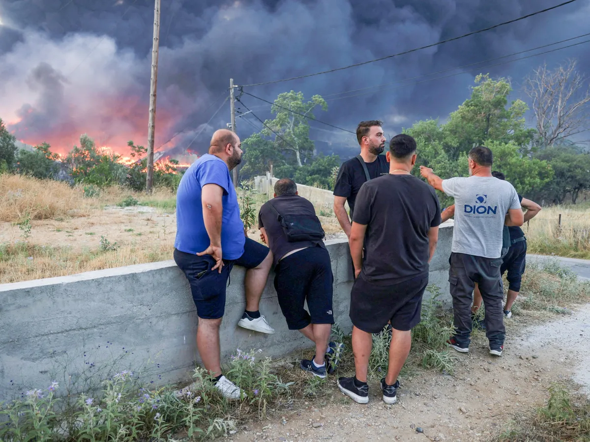
The country, which suffers enormously each summer, is building a growing arsenal of high-tech surveillance to help pre-position firefighters.Local residents look at a burning recycling factory, after a wildfire threatened homes and burned businesses in Oreokastro, on the outskirts of Thessaloniki, Greece, July 5, 2026 [Alexandros Avramidis/Reuters]Published On 16 Jul 2026Athens, Greece – Nine storeys off the surface of the Earth in a northern Athens suburb, half a dozen young engineers are busy reading images from four satellites orbiting 550km (340 miles) above them.The tasking room of the Hellenic Space Center (HSC) at first seems ordinary. It is only the wall-sized screen at the end of the room that offers any hint that something extraordinary is happening here.Recommended Stories list of 4 itemslist 1 of 4More than 2,700 deaths linked to heatwaves in UKlist 2 of 4Hottest June on record in Western Europe as heatwaves hit continentlist 3 of 4Wildfires in southern Spain kill at least 12list 4 of 4Wildfires near Paris force evacuations, disrupt train lines and motorwayend of listThese satellites are Greece’s first with thermal imaging technology and are set to revolutionise fire response in the country at a time when Climate Change is causing drought and frequent Wildfires.By monitoring ground temperature and humidity, they can help predict where a forest fire may happen in the next few hours – a capability the Hellenic Fire Service has never had with such accuracy.Once a fire does break out, the HSC can now model how it will spread by mapping vegetation and elevation, helping to direct fire trucks and, on impassable terrain, foot patrols referred to as forest commandos.These predictive abilities can help the fire service pre-position assets and shorten response times, but the satellites also bring unique properties to a firefight.“When there is a fire, there is a lot of smoke, and these satellites can see through the smoke and find exactly where the hot spots are, where the fires are burning,” HSC President Emmanuel Rammos told Al Jazeera.That can help direct helicopters and planes to perform more precise water bombings.Greek officials are investing in satellite technology as the country regularly suffers from devastating Wildfires [Courtesy: Hellenic Space Centre]“The satellites can tell us where the fire fronts are at night, which is extremely useful for the fire service when it’s planning the first morning water-bombing flights,” Tryfon Farmakakis, a space systems scientist at the HSC, told Al Jazeera.These satellites, which are less than half a metre long, about the size of a briefcase, can also provide tactically important details of the terrain to commanders.“When you are fighting a fire, it’s good to know where the buildings are, if there are high-tension cables, if there are water reservoirs or access roads,” Rammos said.The four satellites form a necklace following the same Earth orbit from the South Pole to the North Pole, and each of them passes over Greece approximately twice a day.To have a constant, real-time picture of the country’s 132,000 square kilometres (51,000 square miles), the HSC has access to about 20 others owned by OroraTech, which built the Greek satellites.Greece is also launching seven more satellites this year, built by Open Cosmos, which will be multi-spectral – meaning they can observe the Earth using different light frequencies.They, too, will help detect fires, but can also monitor environmental health.“They allow us to estimate chlorophyll content, the vitality of vegetation, water stress, the presence of pathogens and the health of forests in general,” said Farmakakis.With 10,000 fires a year, watching forests like a hawkGreece’s fire service has been undergoing a broader technological upgrade.Until two years ago, fire warnings came from patrols, fire engines dispersed on mountains and lookout posts.But Greece now reports about 10,000 forest and field fires a year.Such conventional means cannot cover the terrain, let alone quickly, and early warning is critical to stop any one of these fires from spreading to catastrophic proportions.That is what happened in August 2021, when a fire raged in the posh Athens suburb of Varibobi, requiring dozens of fire trucks, planes and helicopters.At the same time, a small fire near Limni, on the island of Evia, went unattended for two days, until the wind whipped it up into an inferno that devastated the better part of 100,000 hectares (247,100 acres) of pine forest.A firefighter tries to extinguish a blaze in the village of Avgaria, on the island of Evia, Greece, August 10, 2021 [Stelios Misinas/Reuters]It happened again in August 2023, when several simultaneous fires thought to have been sparked by a lightning storm devastated 72,000 hectares (178,000 acres) of Western Thrace and East Macedonia.In 2024, the fire service started using aerial drones. It now flies them 24 hours a day, watching forests and suburban areas across the country.They provide a live video feed and thermal imaging to regional operations centres and a national crisis management centre.“Two years ago, we were operating 40 drones, last year 80, and this year 105,” fire brigadier Alexandros Papaioannou told Al Jazeera. “Drones have changed firefighting operations because until now, fires were spotted by lookouts eight or 10 metres [26 or 32 feet] off the ground. Drones now fly at 120 metres [400 feet], have a more powerful zoom than a pair of binoculars, and can share video for 10 or 15 people to evaluate.”He explained why real-time information is important.“You can put out a fire with a glass of water if you spot it within a minute, and with a bucket of water within two minutes. Every minute that passes it gets bigger,” Papaioannou said.‘Satellites offer the big picture’Drones are also helping the fire service’s forensic department clamp down on fires caused by human activity, whether negligent or malicious.The fire service made 228 arrests in 2022 and 206 arrests in 2023. In 2024 and 2025, when drones were in use, arrests doubled to 430 and 423, respectively.There has been a corresponding rise in fines, from under 300,000 euros ($342,000) in 2022-23 to 1.5 million euros ($1.7m) last year.Drones “contribute decisively” to investigating fires, the Directorate for Countering Crimes of Arson (DAEE) told Al Jazeera, by providing “crucial early evidence … about the direction of the fire and shape of the terrain”, helping to reconstruct the event.Satellites and drones are set to remain a vital part of Greece’s firefighting response, says Iasonas Aliferis, secretary-general of the Association of Graduate Fire Service Officers.“Satellites offer the big picture, drones and aeroplanes offer the tactical picture, and ground personnel offer the operational truth,” Aliferis told Al Jazeera. “We’re moving from a reactive model of response to a model of prevention, monitoring, early warning, rapid reaction and grounded operational decision-making.”
SRCAl Jazeera
LANGEN
LEANCenter
WORDS1 099
ENT12
THU · 2026-07-16 · 08:21 GMTBRIEF NSR-2026-0716-93451
NSR-2026-0716-93451News Report·EN·Technology
Greece pins hopes on heat-seeking satellites to predict wildfires
Greece is enhancing its wildfire response capabilities by deploying four new satellites equipped with thermal imaging technology. These satellites, operated by the Hellenic Space Center (HSC), orbit 550km above Earth and can monitor ground temperature and humidity to predict potential fire outbreaks within hours.
John T PsaropoulosAl JazeeraFiled 2026-07-16 · 08:21 GMTLean · CenterRead · 5 min
Al JazeeraFIG 01
Reading time
5min
Word count
1 099words
Sources cited
2cited
Entities identified
12entities
Quality score
100%
§ 01
Briefing Summary
AI-generatedNEWSAR · AI
Greece is enhancing its wildfire response capabilities by deploying four new satellites equipped with thermal imaging technology. These satellites, operated by the Hellenic Space Center (HSC), orbit 550km above Earth and can monitor ground temperature and humidity to predict potential fire outbreaks within hours. This advanced surveillance allows the Hellenic Fire Service to pre-position firefighters and resources more effectively. The satellites can also penetrate smoke to pinpoint active fire hotspots, enabling more precise aerial water bombings and providing crucial terrain details for ground operations. Greece is further expanding its satellite fleet with seven more multi-spectral satellites to monitor environmental health and detect fires. This technological upgrade is a response to the country's recurring devastating wildfires, which have become more frequent due to climate change.
Confidence 0.90Sources 2Claims 5Entities 12
§ 02
Article analysis
Model · rule-basedFraming
Technology
Environmental
Tone
Measured
AI-assessed
CalmNeutralAlarmist
Factuality
0.80 / 1.00
Factual
LowHigh
Sources cited
2
Limited
FewMany
§ 03
Key claims
5 extracted01
The satellites provide tactical terrain details like buildings, cables, and access roads for firefighters.
quoteEmmanuel Rammos
Confidence
1.00
02
The technology helps direct aerial water bombings and ground patrols more effectively.
factualHellenic Space Center
Confidence
1.00
03
The satellites can see through smoke to identify hot spots and active fire fronts, even at night.
quoteEmmanuel Rammos
Confidence
1.00
04
The satellites can monitor ground temperature and humidity to predict fire locations within hours.
factualHellenic Space Center
Confidence
1.00
05
Greece is using four satellites with thermal imaging technology to help predict wildfires.
factualHellenic Space Center
Confidence
1.00
§ 04
Full report
5 min read · 1 099 words§ 05
Entities
12 identifiedKey playerOppositionContextPositiveNeutralNegative
Organizations4
Locations4
§ 06
Keywords & salience
10 termssatellite technology
1.00
wildfires
1.00
thermal imaging
0.90
fire prediction
0.80
climate change
0.80
fire response
0.70
greece
0.70
drought
0.60
hellenic space center
0.50
water bombing
0.40
§ 07
Topic connections
Interactive graph Network visualization showing 51 related topics
View Full Graph Person Organization Location Event|Click node to navigate|Edge numbers = shared articles