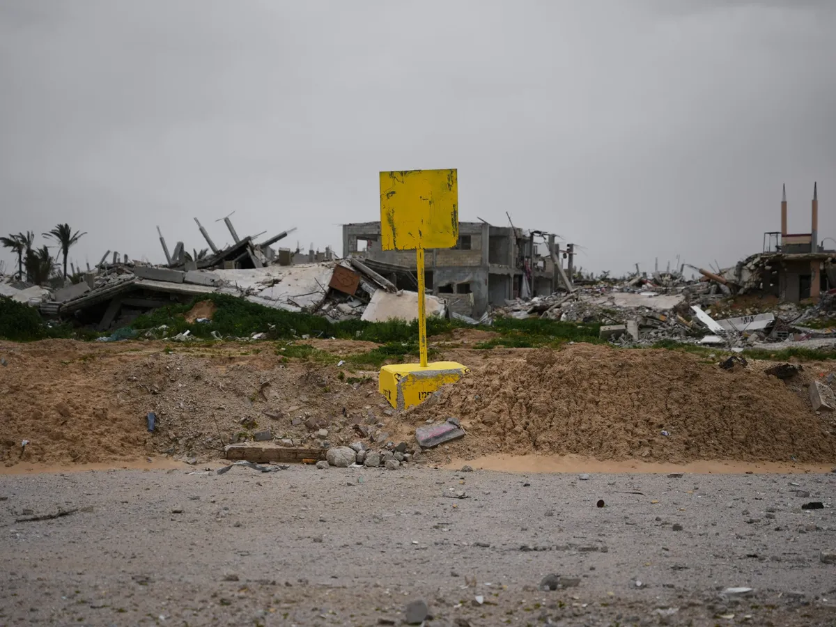
Analysts and locals say the move mirrors what happened after the 1967 war with Israel’s occupation of the West Bank.A yellow block demarcating the 'Yellow Line', which has separated the Gaza Strip's Israeli-held and Palestinian zones since the October 'ceasefire', is visible in Khan Younis, southern Gaza, January 22, 2026 [Abdel Kareem Hana/AP Photo]Published On 22 Jul 2026In Gaza, the Israeli military only needs to move a yellow concrete block a few metres to rewrite the geography on the ground. Originally placed as field markers following the ceasefire to separate Israeli forces from areas slated for withdrawal, these blocks have transformed into an advancing front line.According to the Office for the Coordination of Humanitarian Affairs (OCHA), this restricted access zone, which Israel calls the “Yellow Line“, expanded to cover 64.9 percent of the Gaza Strip by June 2026, up from 53 percent earlier in the year.For Palestinians, these shifting markers are a daily reality of forced displacement. The Government Media Office in Gaza has recorded 3,795 Israeli violations of the ceasefire, resulting in 1,168 Palestinians killed since the “ceasefire” agreement in October last year. UN data indicates that roughly a third of these deaths occurred in areas near this advancing demarcation line.A waking nightmare in Deir el-BalahFollowing evacuation orders broadcasted by Israeli quadcopters on the evening of Friday, July 17, Hazem Saeed, a resident of eastern Deir el-Balah, told Al Jazeera that military vehicles advanced under the cover of darkness.They pushed the yellow blocks between 300 and 350 metres (984 to 1,148 feet) westwards, threatening to shoot anyone who refused to leave.The sudden shift placed the concrete barriers directly on Sultan Othman Street, confiscating vast agricultural and residential lands belonging to the Abu Ghraba, Abu Ghaliba, Abu Blima, and al-Tarhouni families.“The yellow cube is now placed two to four metres (6 to 13 feet) from citizens’ homes,” Saeed explained. He noted that families such as Bin Saeed, al-Louh, and Abu Ghraba now find themselves living immediately west of the line, having lost the agricultural lands that were their sole livelihood.‘A creeping death’ in ZeitounIn the Zeitoun neighbourhood, east of Gaza City, 71 displaced families set up a makeshift camp called Ahl al-Sumud (People of Steadfastness) on Salah al-Din Street, just 70 metres (230 feet) from the “Yellow Line”. Camp supervisor Ramadan Abu Ammo told Al Jazeera that they did not choose the location for safety, but they had nowhere else to go.“We are carrying our souls on our palms, but where do we go? We have no other place,” Abu Ammo said, noting that shrapnel falls almost daily. He added that his parents remain buried under the rubble of his nearby home, as rescue teams are barred from accessing the newly restricted area.Palestinian journalist Saed Hassaballah, who lives near the camp, described the advancing blocks as a “creeping death”, explaining that intense gunfire and shelling always precede their movement. He told Al Jazeera that residents endure live fire aimed directly at their homes to push them out, stating, “The occupation wants to drive us out by force, but the people are holding onto their land.”Erasing the northIn northern Gaza, the advancement of the “Yellow Line” is accompanied by a complete erasure of the landscape. Resident Suhail Ouda told Al Jazeera that the line had advanced up to 1.5km (about 1 mile), stretching from as-Sikka Street near Beit Hanoon to Trans Street near the Sheikh Zayed roundabout. He described how Israeli bulldozers flatten homes daily, while quadcopters detonate remaining structures behind the line.According to Ouda, Israeli forces have erected massive earthen barriers at the Tal az-Zaatar heights, installing watchtowers that provide direct oversight of the area. This has turned the neighbourhood into an open military surveillance zone.He also reported that local armed groups loyal to Israel routinely detain and assault youths near the line, citing a recent incident where a young man was beaten near the Janzir roundabout in Beit Lahiya and handed over to the army.Annexation by design and paralysed servicesThe expansion paralyses civil life across the Palestinian territory. Mohammed al-Sarsawi, head of media for the Gaza municipality, told Al Jazeera that municipal teams can no longer access nearly half of Gaza City, including Shujayea, eastern Tuffah, Zeitoun and parts of Daraj.The advancing lines have isolated vital water wells, sewage facilities and main control rooms. With more than half of the city’s 950,000 residents crammed into a fraction of its original space, al-Sarsawi warned that the pressure on crumbling infrastructure threatens a prolonged environmental and health catastrophe.These field testimonies align with a deliberate strategy to solidify military control. Political analyst Ahmed al-Tanani observed that Israel is transitioning from a phased withdrawal to expanding its territorial grip from 195sq km (75.3sq miles) to 235sq km (90.7sq miles). He warned that creating military posts along the line mirrors what followed the 1967 war, when the West Bank was occupied — aiming to transform a temporary presence into long-term settlements.This entrenchment is corroborated by an investigation from Al Jazeera’s Open Source Unit, which identified 40 permanent Israeli military outposts across Gaza, with several built entirely from scratch after last year’s “ceasefire”.The intent to annex is openly echoed by Israeli leadership. During a recent rally, National Security Minister Itamar Ben-Gvir celebrated the expansion, declaring, “If someone had said three years ago that we would control 70 percent of the Gaza Strip, no one would have believed it … Gaza is ours.”Meanwhile, humanitarian aid into Gaza and civilian travel out of the territory remain severely restricted, with Israel’s compliance rates for both hovering around 35 percent, leaving the enclave suffocated behind a continuously shifting border.
SRCAl Jazeera
LANGEN
LEANCenter
WORDS930
ENT12
WED · 2026-07-22 · 11:52 GMTBRIEF NSR-2026-0722-95032
NSR-2026-0722-95032News Report·EN·Human Rights
‘Creeping death’: Israel weaponises ‘Yellow Line’ to annex Gaza
Israel is expanding a restricted zone in Gaza, referred to as the "Yellow Line," by moving yellow concrete blocks. This zone, initially established after a ceasefire, has grown significantly, covering 64.9 percent of Gaza by June 2026.
By Yosra AkloukAl JazeeraFiled 2026-07-22 · 11:52 GMTLean · CenterRead · 4 min
Al JazeeraFIG 01
Reading time
4min
Word count
930words
Sources cited
4cited
Entities identified
12entities
Quality score
100%
§ 01
Briefing Summary
AI-generatedNEWSAR · AI
Israel is expanding a restricted zone in Gaza, referred to as the "Yellow Line," by moving yellow concrete blocks. This zone, initially established after a ceasefire, has grown significantly, covering 64.9 percent of Gaza by June 2026. The expansion has led to forced displacement of Palestinians, with many losing agricultural lands and homes. The movement of these blocks is often preceded by gunfire and shelling, and is accompanied by the destruction of infrastructure. This expansion is paralyzing civil services, including access to water and sewage facilities, and is described by locals and analysts as a form of annexation, mirroring Israel's occupation of the West Bank after 1967.
Confidence 0.90Sources 4Claims 5Entities 12
§ 02
Article analysis
Model · rule-basedFraming
Human Rights
Political Strategy
Tone
Sensational
AI-assessed
CalmNeutralAlarmist
Factuality
0.60 / 1.00
Mixed
LowHigh
Sources cited
4
Well sourced
FewMany
§ 03
Key claims
5 extracted01
The 'Yellow Line' demarcation zone in Gaza expanded to cover 64.9% of the Strip by June 2026, up from 53% earlier in the year.
statisticOffice for the Coordination of Humanitarian Affairs (OCHA)
Confidence
0.90
02
Roughly a third of Palestinian deaths occurred in areas near the advancing demarcation line.
statisticUN data
Confidence
0.85
03
3,795 Israeli violations of the ceasefire have been recorded, resulting in 1,168 Palestinians killed since October.
statisticGovernment Media Office in Gaza
Confidence
0.80
04
The advancing blocks are described by a journalist as a 'creeping death'.
quoteSaed Hassaballah (Palestinian journalist)
Confidence
0.75
05
Israeli military vehicles advanced under darkness, pushing yellow blocks 300-350 meters westwards and confiscating agricultural and residential lands.
quoteHazem Saeed (resident)
Confidence
0.70
§ 04
Full report
4 min read · 930 words§ 05
Entities
12 identifiedKey playerOppositionContextPositiveNeutralNegative
Organizations3
§ 06
Keywords & salience
8 termsgaza strip
1.00
yellow line
1.00
annexation
0.90
forced displacement
0.80
israeli occupation
0.70
ceasefire violations
0.60
humanitarian impact
0.50
geographical changes
0.40
§ 07
Topic connections
Interactive graph Network visualization showing 51 related topics
View Full Graph Person Organization Location Event|Click node to navigate|Edge numbers = shared articles