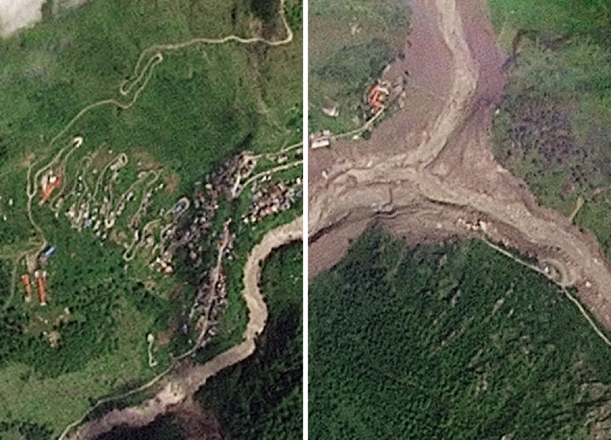
A glacier collapse high in the Himalayas on Wednesday triggered catastrophic flooding along the Nepal-Tibet border.At least 359 people have been confirmed dead and more than 1,300 remain missing across Nepal and China’s Tibet region after a Himalayan glacier collapse sent a wall of water, mud and rock through border towns and valleys.Rescue teams are searching for survivors in terrain that is hard to access at the best of times. At least 19 bridges and about 40km (25 miles) of road have been destroyed, further hampering the search.Nepal-police" class="entity-link entity-organization" data-entity-id="36616" data-entity-type="organization">Nepal Police spokesperson Abi Narayan Kafle said the death toll is expected to rise further.(Al Jazeera)Satellite imagery captured by Planet Labs before and after the flood shows how buildings and roads have been washed away.The imagery also shows large parts of Syapru Besi village submerged in mud.A drone view shows mud covering properties following a flash flood in Trishuli, Nuwakot district, Nepal [Navesh Chitrakar/Reuters]Dozens of bridges have been destroyed and nearly 40 kilometres (25 miles) of roads damaged, complicating search efforts, Nepali officials say [Navesh Chitrakar/Reuters]A drone view shows mud covering buildings in Trishuli, Nuwakot district [Navesh Chitrakar/Reuters]An aerial view shows workers using excavators to clear sludge following flash floods at Trishuli in Nepal’s Nuwakot district on August 27, 2026 [Arun Sankar/AFP]What happened?At about 8:40am local time (02:55 GMT) on Wednesday, a large section of glacier broke away high above the Lhende river in Tibet. The falling ice and rock dammed the river and, shortly afterwards, when the blockage gave way, the surge tore through settlements in Nepal’s Rasuwa district, destroying homes, hydropower plants and border infrastructure.The resulting ice and rock avalanche struck the river about 20km (12 miles) northeast of the Rasuwagadhi border crossing.Early reports attributed the collapse to a magnitude 4.4 earthquake. But the United States Geological Survey later said the seismic signal was caused by the landslide itself, not an earthquake. The landslide packed enough force to register as a magnitude 5.2 seismic event.A drone view shows mud covering properties following a flash flood at Trishuli in Nuwakot district, Nepal, on August 26, 2026 [Stringer/Reuters]Where did the floods hit?
SRCAl Jazeera
LANGEN
LEANCenter
WORDS349
ENT12
THU · 2026-08-27 · 11:54 GMTBRIEF NSR-2026-0827-106488
NSR-2026-0827-106488News Report·EN·Human Interest
Satellite images show destruction from Nepal-Tibet floods
A Himalayan glacier collapse on Wednesday triggered catastrophic flooding along the Nepal-Tibet border, resulting in at least 359 confirmed deaths and over 1,300 missing. The event occurred when a large section of glacier broke away high above the Lhende river in Tibet, damming the river before the blockage gave way, sending a surge of water, mud, and rock through border towns and valleys.
AJLabsAl JazeeraFiled 2026-08-27 · 11:54 GMTLean · CenterRead · 2 min
Al JazeeraFIG 01
Reading time
2min
Word count
349words
Sources cited
4cited
Entities identified
12entities
Quality score
100%
§ 01
Briefing Summary
AI-generatedNEWSAR · AI
A Himalayan glacier collapse on Wednesday triggered catastrophic flooding along the Nepal-Tibet border, resulting in at least 359 confirmed deaths and over 1,300 missing. The event occurred when a large section of glacier broke away high above the Lhende river in Tibet, damming the river before the blockage gave way, sending a surge of water, mud, and rock through border towns and valleys. The destruction of at least 19 bridges and approximately 40 kilometers of road is significantly hampering rescue efforts. Satellite imagery confirms the widespread destruction of buildings and roads, with villages submerged in mud. The United States Geological Survey determined the seismic signal was caused by the landslide itself, not an earthquake.
Confidence 0.90Sources 4Claims 5Entities 12
§ 02
Article analysis
Model · rule-basedFraming
Human Interest
Environmental
Tone
Mixed Tone
AI-assessed
CalmNeutralAlarmist
Factuality
0.90 / 1.00
Factual
LowHigh
Sources cited
4
Well sourced
FewMany
§ 03
Key claims
5 extracted01
The seismic signal was caused by the landslide itself, not an earthquake, and registered as a magnitude 5.2 seismic event.
factualUnited States Geological Survey
Confidence
1.00
02
Satellite imagery shows destruction, with buildings and roads washed away and parts of Syapru Besi village submerged in mud.
factualPlanet Labs
Confidence
1.00
03
A glacier collapse in the Himalayas triggered catastrophic flooding along the Nepal-Tibet border.
factual
Confidence
1.00
04
At least 19 bridges and about 40km (25 miles) of road have been destroyed, hampering the search.
statistic
Confidence
0.90
05
At least 359 people have been confirmed dead and more than 1,300 remain missing across Nepal and China’s Tibet region.
statistic
Confidence
0.90
§ 04
Full report
2 min read · 349 words§ 05
Entities
12 identifiedKey playerOppositionContextPositiveNeutralNegative
Organizations5
Locations4
§ 06
Keywords & salience
10 termscatastrophic flooding
1.00
glacier collapse
1.00
nepal-tibet border
0.90
himalayas
0.80
satellite imagery
0.70
mudslide
0.60
landslide
0.60
search and rescue
0.50
infrastructure destruction
0.50
seismic event
0.40
§ 07
Topic connections
Interactive graph Network visualization showing 51 related topics
View Full Graph Person Organization Location Event|Click node to navigate|Edge numbers = shared articles