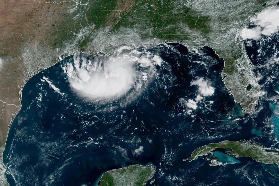
Tropical Storm Edouard heads for Texas and Louisiana while a storm moves toward Hawaii 1 of 4 | Texas Governor Greg Abbott said the biggest problem expected from the storm is flooding after the National Hurricane Center issued a tropical storm warning on Monday, as more than 4 inches (10 centimeters) per hour could fall and will likely cause flash flooding in low-lying and urban areas. 2 of 4 | This satellite image released by NOAA shows Potential Tropical Cyclone Five forming over the Gulf of Mexico on Monday, Aug. 31, 2026. (NOAA via AP) 3 of 4 | This satellite image released by NOAA shows Tropical Storm Lowell over the Pacific Ocean, Monday, Aug. 31, 2026. (NOAA via AP) 4 of 4 | This satellite image released by NOAA shows Hurricane Karina strengthening off the southern tip of Baja California on Sunday, Aug. 30, 2026. (NOAA via AP) 1 of 4 Texas Governor Greg Abbott said the biggest problem expected from the storm is flooding after the National Hurricane Center issued a tropical storm warning on Monday, as more than 4 inches (10 centimeters) per hour could fall and will likely cause flash flooding in low-lying and urban areas. Add AP News on Google Add AP News as your preferred source to see more of our stories on Google. Share 2 of 4 | This satellite image released by NOAA shows Potential Tropical Cyclone Five forming over the Gulf of Mexico on Monday, Aug. 31, 2026. (NOAA via AP) 2 of 4 This satellite image released by NOAA shows Potential Tropical Cyclone Five forming over the Gulf of Mexico on Monday, Aug. 31, 2026. (NOAA via AP) Add AP News on Google Add AP News as your preferred source to see more of our stories on Google. Share 3 of 4 | This satellite image released by NOAA shows Tropical Storm Lowell over the Pacific Ocean, Monday, Aug. 31, 2026. (NOAA via AP) 3 of 4 This satellite image released by NOAA shows Tropical Storm Lowell over the Pacific Ocean, Monday, Aug. 31, 2026. (NOAA via AP) Add AP News on Google Add AP News as your preferred source to see more of our stories on Google. Share 4 of 4 | This satellite image released by NOAA shows Hurricane Karina strengthening off the southern tip of Baja California on Sunday, Aug. 30, 2026. (NOAA via AP) 4 of 4 This satellite image released by NOAA shows Hurricane Karina strengthening off the southern tip of Baja California on Sunday, Aug. 30, 2026. (NOAA via AP) Add AP News on Google Add AP News as your preferred source to see more of our stories on Google. Share MIAMI (AP) — Tropical Storm Edouard was heading toward the Gulf Coast early Tuesday and expected to gain strength before bringing potentially heavy rains and flooding into parts of Texas and Louisiana.The storm was upgraded Monday night from a tropical depression and forecasters with the National Hurricane Center expect it will make landfall in Texas later on Tuesday.Early Tuesday the storm was about 65 miles (100 kilometers) south-southeast of Cameron, Louisiana, and 90 miles (145 kilometers) southeast of Port Arthur, Texas, with maximum sustained winds of 40 mph (65 kph) while moving west-northwest at 8 mph (13 kph).Texas Gov. Greg Abbott said the biggest problem expected from the storm is flooding. Forecasters are anticipating 3-6 inches (7-15 centimeters) of rain in the greater Houston area, with some areas of the state’s upper coast getting up to 9 inches (22 centimeters). More than 4 inches (10 centimeters) per hour could fall and will likely cause flash flooding in low-lying and urban areas, according to the National Hurricane Center. “This is our first big storm of the season, and I’ll tell you, Texas is prepared,” Orlando Alanis of the Texas Division of Emergency Management said during a news conference.Crews worked Monday to clear dry vegetation that could ignite from a lightning strike and cause fast-spreading fires, Abbott said. 4 MIN READ 4 MIN READ 1 MIN READ Meanwhile, the remnants of Hurricane Dolly brought rain and thunderstorms to parts of Haiti and the Dominican Republic, the Turks & Caicos, and the Bahamas, the hurricane center said. In the Pacific Ocean on Monday evening, Tropical Storm Lowell was about 630 miles (1,015 kilometers) southeast of Hilo, Hawaii, and moving west with maximum sustained winds of 70 mph (110 kph) while moving west at 10 mph (17 kph). Forecasters said Lowell could rapidly intensify and become a major hurricane by Wednesday. Elsewhere in the Pacific, Hurricane Karina became a hurricane Sunday, fueled by warm waters far from any shore, and strengthened Monday into a powerful Category 4 storm. But it did not threaten land, forecasters said. On Tuesday morning, Karina remained a Category 4 hurricane and was centered 1,210 miles (1,950 kilometers) west-southwest of the southern tip of the Baja California peninsula of Mexico with maximum sustained winds of 140 mph (222 kph) while moving west-northwest at 10 mph (17 kph), the center said.
SRCAssociated Press (AP)
LANGEN
LEANCenter
WORDS837
ENT12
TUE · 2026-09-01 · 09:53 GMTBRIEF NSR-2026-0901-108032
NSR-2026-0901-108032News Report·EN·Environmental
Tropical Storm Edouard heads for Texas and Louisiana while a storm moves toward Hawaii
Tropical Storm Edouard is heading towards the Texas and Louisiana Gulf Coast, expected to strengthen before bringing heavy rains and potential flooding. The storm, upgraded from a tropical depression on Monday night, was forecast to make landfall in Texas on Tuesday.
Updated [hour]:[minute] [AMPM] [timezone], [monthFull] [day], [year]Associated Press (AP)Filed 2026-09-01 · 09:53 GMTLean · CenterRead · 4 min
Associated Press (AP)FIG 01
Reading time
4min
Word count
837words
Sources cited
2cited
Entities identified
12entities
Quality score
100%
§ 01
Briefing Summary
AI-generatedNEWSAR · AI
Tropical Storm Edouard is heading towards the Texas and Louisiana Gulf Coast, expected to strengthen before bringing heavy rains and potential flooding. The storm, upgraded from a tropical depression on Monday night, was forecast to make landfall in Texas on Tuesday. Forecasters anticipate 3-6 inches of rain in the Houston area, with some coastal regions possibly receiving up to 9 inches, leading to flash flooding concerns. Texas officials stated the state is prepared for the storm. Meanwhile, Tropical Storm Lowell is moving towards Hawaii and could intensify into a major hurricane, while Hurricane Karina, a Category 4 storm, is in the Pacific but not threatening land.
Confidence 0.90Sources 2Claims 5Entities 12
§ 02
Article analysis
Model · rule-basedFraming
Environmental
Public Health
Tone
Measured
AI-assessed
CalmNeutralAlarmist
Factuality
0.90 / 1.00
Factual
LowHigh
Sources cited
2
Limited
FewMany
§ 03
Key claims
5 extracted01
Tropical Storm Lowell is over the Pacific Ocean.
factual
Confidence
0.95
02
Tropical Storm Edouard is heading toward the Gulf Coast and expected to gain strength.
factual
Confidence
0.95
03
More than 4 inches (10 centimeters) per hour could fall and will likely cause flash flooding in low-lying and urban areas.
statisticNational Hurricane Center
Confidence
0.90
04
The biggest problem expected from the storm is flooding.
quoteTexas Governor Greg Abbott
Confidence
0.90
05
Tropical Storm Edouard is expected to make landfall in Texas later on Tuesday.
predictionforecasters with the National Hurricane Center
Confidence
0.85
§ 04
Full report
4 min read · 837 words§ 05
Entities
12 identifiedKey playerOppositionContextPositiveNeutralNegative
Locations7
§ 06
Keywords & salience
10 termstropical storm edouard
1.00
flooding
0.90
texas
0.80
louisiana
0.70
hawaii
0.60
tropical storm warning
0.50
national hurricane center
0.50
gulf of mexico
0.40
pacific ocean
0.40
flash flooding
0.40
§ 07
Topic connections
Interactive graph Network visualization showing 6 related topics
View Full Graph Person Organization Location Event|Click node to navigate|Edge numbers = shared articles