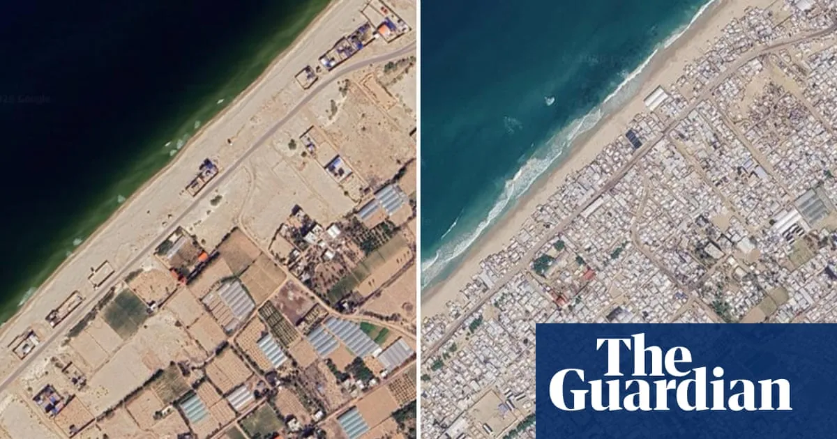
An update to Google Maps has revealed the extent of devastation during the three-year Gaza war and the severity of the continuing humanitarian crisis faced by the territory’s 2.3 million inhabitants.The images were taken in June this year and show further destruction of homes, businesses, places of worship and infrastructure since a fragile ceasefire came into effect almost 12 months ago.Gaza 2023-2026: al-Mawasi, RafahThey show huge tented camps lining much of the shoreline, often within a few metres of the sea. Gaza’s once busy main port, now badly damaged and empty of fishing boats, is surrounded by makeshift accommodation. Any available open space in Gaza City is packed with shacks, tents and huts.Gaza 2023-2026: Tel al-Sultan, RafahThe images also show massive damage to northern towns such as Beit Lahiya and Beit Hanoun, as well as the destruction of places of worship such as the Istiqlal mosque in Khan Younis. Major neighbourhoods in Gaza City such as Jabaliya and Shuja’iya, which were targeted in repeated Israeli offensives, are clearly now uninhabitable.Swaths of rubble are visible in the south of Gaza, where a wide strip appears to have been cleared by Israeli forces along the border with Egypt. The town of Rafah appears to have been almost entirely reduced to rubble and Tel al-Sultan razed to the ground.Gaza 2023-2026: Istiqlal Mosque, Khan YounisMore than 2.1 million displaced people are living in tents and temporary shelters in Gaza, where about 82% of structures – roughly 200,000 buildings – have been damaged, with about two-thirds of those destroyed, according to the UN agency for Palestinian refugees, UNRWA.A recent UN assessment estimated that the number of destroyed structures across Gaza had increased by 9% since the declaration of a ceasefire in October 2025.Gaza 2023-2026: Beit Lahiya“The estimate of the total amount of rubble in Gaza is 61m tonnes. It is approximately 20 times the amount of rubble generated in all wars across the world over the last 18 years,” Jaco Cilliers, the UN-development-programme" class="entity-link entity-organization" data-entity-id="121801" data-entity-type="organization">UN Development Programme’s special representative in Palestine told the Guardian last month. The presence of human remains still buried under the rubble remains one of the most urgent humanitarian problems.More than 74,000 Palestinians have been killed in Gaza since the start of the war, mostly civilians. The conflict was triggered by a surprise attack by Hamas into Israel in October 2023, in which militants killed about 1,200 people, mostly civilians, and took 251 others hostage.
SRCThe Guardian - World News
LANGEN
LEANCenter-Left
WORDS402
ENT12
THU · 2026-10-01 · 04:00 GMTBRIEF NSR-2026-1001-115457
NSR-2026-1001-115457News Report·EN·Conflict
New Google Maps images reveal massive scale of devastation in Gaza
New Google Maps satellite imagery from June 2026 reveals the extensive destruction in Gaza following a three-year conflict. The images show widespread damage to homes, businesses, and places of worship, with makeshift shelters and tent camps lining the coast and filling open spaces.
Jason Burke and Eithne StauntonThe Guardian - World NewsFiled 2026-10-01 · 04:00 GMTLean · Center-LeftRead · 2 min
The Guardian - World NewsFIG 01
Reading time
2min
Word count
402words
Sources cited
2cited
Entities identified
12entities
Quality score
100%
§ 01
Briefing Summary
AI-generatedNEWSAR · AI
New Google Maps satellite imagery from June 2026 reveals the extensive destruction in Gaza following a three-year conflict. The images show widespread damage to homes, businesses, and places of worship, with makeshift shelters and tent camps lining the coast and filling open spaces. Major neighborhoods in Gaza City and northern towns are depicted as uninhabitable, and the town of Rafah appears largely reduced to rubble. This devastation has led to over 2.1 million displaced people living in temporary shelters, with an estimated 82% of structures damaged and two-thirds destroyed. The scale of rubble is immense, posing significant humanitarian challenges, including the presence of human remains.
Confidence 0.90Sources 2Claims 5Entities 12
§ 02
Article analysis
Model · rule-basedFraming
Conflict
Human Interest
Tone
Mixed Tone
AI-assessed
CalmNeutralAlarmist
Factuality
0.80 / 1.00
Factual
LowHigh
Sources cited
2
Limited
FewMany
§ 03
Key claims
5 extracted01
More than 74,000 Palestinians have been killed in Gaza since the start of the war.
statistic
Confidence
1.00
02
The total amount of rubble in Gaza is 61m tonnes, approximately 20 times the amount of rubble generated in all wars across the world over the last 18 years.
statisticJaco Cilliers, UN Development Programme’s special representative in Palestine
Confidence
1.00
03
About 82% of structures in Gaza (roughly 200,000 buildings) have been damaged, with about two-thirds destroyed.
statisticUN agency for Palestinian refugees, Unrwa
Confidence
1.00
04
More than 2.1 million displaced people are living in tents and temporary shelters in Gaza.
statisticUN agency for Palestinian refugees, Unrwa
Confidence
1.00
05
New Google Maps images reveal the extent of devastation in Gaza, showing destruction of homes, businesses, places of worship, and infrastructure.
factual
Confidence
1.00
§ 04
Full report
2 min read · 402 words§ 05
Entities
12 identifiedKey playerOppositionContextPositiveNeutralNegative
Organizations5
Locations4
§ 06
Keywords & salience
10 termsdevastation
1.00
gaza war
1.00
humanitarian crisis
0.90
google maps
0.80
destruction
0.80
displaced people
0.70
rubble
0.60
infrastructure
0.50
ceasefire
0.50
unrwa
0.40
§ 07
Topic connections
Interactive graph Network visualization showing 51 related topics
View Full Graph Person Organization Location Event|Click node to navigate|Edge numbers = shared articles