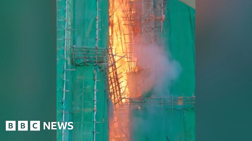
BBC Verify has geolocated video footage which appears to show the early stages of a fire at a high-rise public housing complex in Hong Kong - and how fast the blaze took hold.The video shows a fire in Wang Cheong House which tallies with an account given by the deputy director of Hong Kong Fire Services, Derek Armstrong Chan, who confirmed the location the fire started.According to the person who posted the video on social media site Threads, they heard banging sounds before seeing the fire at 14:51 local time (06:51 GMT).They said the first firefighters arrived six minutes later, by which time the fire had spread to the fourth floor.The blaze, which has spread through seven tower blocks in Tai Po district, has killed at least 75 people, while nearly 300 remain missing.Follow live coverage here
SRCBBC News - World
LANGEN
LEANCenter
WORDS137
ENT3
THU · 2025-11-27 · 12:52 GMTBRIEF NSR-2025-1127-024
NSR-2025-1127-024News Report·EN·Human Interest
Video shows speed fire spreads in Hong Kong tower block
A video posted on social media shows the early stages of a fire at Wang Cheong House in Hong Kong's public housing complex, which has since spread to seven tower blocks in Tai Po district. The blaze started at 14:51 local time and was reported by residents who heard banging sounds before seeing the fire.
BBC News - WorldFiled 2025-11-27 · 12:52 GMTLean · CenterRead · 1 min
BBC News - WorldFIG 01
Reading time
1min
Word count
137words
Sources cited
2cited
Entities identified
3entities
Quality score
100%
§ 01
Briefing Summary
AI-generatedNEWSAR · AI
A video posted on social media shows the early stages of a fire at Wang Cheong House in Hong Kong's public housing complex, which has since spread to seven tower blocks in Tai Po district. The blaze started at 14:51 local time and was reported by residents who heard banging sounds before seeing the fire. Firefighters arrived six minutes later and found the fire had already spread to the fourth floor. At least 75 people have been killed, with nearly 300 remaining missing. The cause of the fire is currently unknown. The incident highlights the rapid spread of the blaze, which has raised concerns about safety measures in Hong Kong's public housing complex.
Confidence 0.85Sources 2Claims 5Entities 3
§ 02
Article analysis
Model · rule-basedFraming
Human Interest
Public Health
Tone
Mixed Tone
AI-assessed
CalmNeutralAlarmist
Factuality
0.90 / 1.00
Factual
LowHigh
Sources cited
2
Limited
FewMany
§ 03
Key claims
5 extracted01
At least 75 people have died in the fire.
statistic
Confidence
1.00
02
The blaze has spread through seven tower blocks in Tai Po district.
factual
Confidence
1.00
03
The fire started in Wang Cheong House.
factualDerek Armstrong Chan, deputy director of Hong Kong Fire Services
Confidence
1.00
04
Video footage shows the early stages of a fire at a high-rise public housing complex in Hong Kong.
factualBBC Verify
Confidence
1.00
05
The first firefighters arrived six minutes after the fire was spotted.
factualPerson who posted the video on Threads
Confidence
0.80
§ 04
Full report
1 min read · 137 words§ 05
Entities
3 identifiedKey playerOppositionContextPositiveNeutralNegative
§ 06
Keywords & salience
6 termsfire
0.80
hong kong
0.70
tower block
0.60
fire spread
0.50
high-rise building
0.40
public housing
0.40
§ 07
Topic connections
Interactive graph Network visualization showing 51 related topics
View Full Graph Person Organization Location Event|Click node to navigate|Edge numbers = shared articles