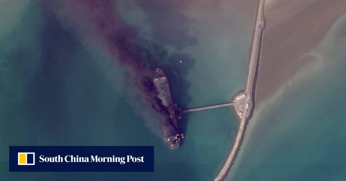
Satellite images are beginning to be released, giving a glimpse into the toll of the Iran-war" class="entity-link entity-event" data-entity-id="38748" data-entity-type="event">Iran war, with ships ablaze in an Iranian port and destroyed buildings at an American base.Information has so far been scarce about the damage being done across the Middle East, particularly when it’s inside closed military facilities, since the start of the war on February 28.The images come from Planet Labs PBC, a San Francisco-based firm used by media outlets, including Associated Press. Planet Labs has put a two-week delay on its imagery becoming public, citing concerns its imagery could be used by “adversarial actors”.High-resolution images have also been published by competing firms. Other providers, like the US Geological Survey, have been publishing lower-resolution imagery as well that has been useful.The US and Israel have been striking a wide variety of targets, including leadership figures, military bases, missile and air defence sites and positions of the paramilitary Revolutionary Guard and its volunteer force, the Basij. Iran has responded with drone and missile fire targeting Israel and nearby Gulf Arab nations.Smoke billowing following an explosion at the Iranian port of Bandar Abbas on March 2. Photo: Planet Labs PBC via AFPBurning ships in Bandar Abbas, Iran
SRCSouth China Morning Post
LANGEN
LEANCenter-Right
WORDS200
ENT11
WED · 2026-03-18 · 06:15 GMTBRIEF NSR-2026-0318-25551
NSR-2026-0318-25551News Report·EN·Conflict
Satellite images reveal damage of the widening Middle East war
Satellite images are providing a first look at the damage caused by the widening Middle East war, which began on February 28th. Images from firms like Planet Labs PBC show burning ships in the Iranian port of Bandar Abbas and destroyed buildings at an American base.
Associated PressSouth China Morning PostFiled 2026-03-18 · 06:15 GMTLean · Center-RightRead · 1 min
South China Morning PostFIG 01
Reading time
1min
Word count
200words
Sources cited
2cited
Entities identified
11entities
Quality score
100%
§ 01
Briefing Summary
AI-generatedNEWSAR · AI
Satellite images are providing a first look at the damage caused by the widening Middle East war, which began on February 28th. Images from firms like Planet Labs PBC show burning ships in the Iranian port of Bandar Abbas and destroyed buildings at an American base. The release of these images has been delayed by some firms due to concerns about potential misuse by adversarial actors. The US and Israel have been striking targets including military bases and missile sites, while Iran has responded with drone and missile attacks. These images offer a rare glimpse into the extent of the damage within military facilities amidst limited information.
Confidence 0.90Sources 2Claims 5Entities 11
§ 02
Article analysis
Model · rule-basedFraming
Conflict
National Security
Tone
Measured
AI-assessed
CalmNeutralAlarmist
Factuality
0.80 / 1.00
Factual
LowHigh
Sources cited
2
Limited
FewMany
§ 03
Key claims
5 extracted01
Planet Labs PBC puts a two-week delay on its imagery becoming public.
factualPlanet Labs PBC
Confidence
1.00
02
The war started on February 28.
factual
Confidence
1.00
03
Satellite images reveal damage from the Iran war, including burning ships and destroyed buildings.
factual
Confidence
0.90
04
Iran has responded with drone and missile fire targeting Israel and nearby Gulf Arab nations.
factual
Confidence
0.80
05
The US and Israel have been striking targets including leadership figures and military bases.
factual
Confidence
0.80
§ 04
Full report
1 min read · 200 words§ 05
Entities
11 identifiedKey playerOppositionContextPositiveNeutralNegative
Organizations4
Locations6
Events1
§ 06
Keywords & salience
10 termssatellite images
1.00
middle east war
0.90
iran
0.80
damage assessment
0.70
military facilities
0.60
us
0.60
missile fire
0.50
israel
0.50
bandar abbas
0.40
planet labs
0.40
§ 07
Topic connections
Interactive graph Network visualization showing 51 related topics
View Full Graph Person Organization Location Event|Click node to navigate|Edge numbers = shared articles