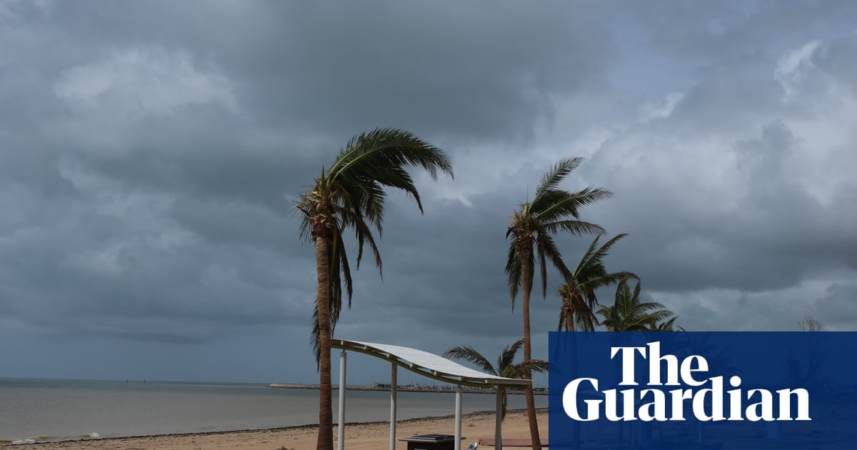
The aftermath of ex-Tropical Cyclone Narelle in Exmouth, Western Australia, on Saturday. Photograph: Zac Saber View image in fullscreen The aftermath of ex-Tropical Cyclone Narelle in Exmouth, Western Australia, on Saturday. Photograph: Zac Saber ‘No one has had a dry run’: weather warnings for storm-ravaged WA after Cyclone Narelle downgraded to tropical low Major gas infrastructure hit by outages as weather system continues south-east Get our breaking news email, free app or daily news podcast Zac Saber did not sleep a wink as ex-Tropical Cyclone Narelle battered the Western Australian coast on Friday night. As fellow Exmouth locals took shelter in evacuation centres and homes, Saber spent the night listening to the sound of “super intense” winds rattling his walls. “The windows looked like they were going to pop, there were crazy sounds coming from the door and roof,” he said. “We had to find buckets … rain was coming through at a full-on horizontal direction, underneath windowsills.” View image in fullscreen A damaged boat at the marina in Exmouth, where winds exceeded 250km/h. Photograph: Zac Saber View image in fullscreen Exmouth bore the brunt of the storm when it was at category four level. Exmouth, 1,250km north of Perth, bore the brunt of the storm when it was at category four level. Winds exceeding 250km/h tore roofs from buildings and caused widespread flooding. In a dramatic scene on Friday, 50 people were forced to flee the town’s primary evacuation centre after the building itself sustained wind damage. By Saturday morning, as the storm was downgraded to a tropical low and winds finally eased around 11am, Saber began hearing community reports of the destruction. “I’ve heard of people losing roofs, and even a report of a dinghy in a living room,” he said. Saber, the manager of the Minderoo Exmouth research lab, found his facility had escaped major structural damage – though there was “some water.” “Some businesses were smashed hard, the power’s still off, apparently the IGA is in a bad way and the Ampol fuel station is damaged.” View image in fullscreen Strong winds and heavy rain lashed the town of Onslow on Friday. Photograph: Justin Hayes/PR IMAGE The system continued to lose intensity as it swept south-east, bringing gusts of up to 100km/h, heavy rainfall and flash flood warnings for the wheatbelt region and Perth. The system was expected to continue moving south-east from Geraldton before likely exiting the south coast later on Saturday, with conditions expected to ease into Sunday, the Bureau of Meteorology said. The cyclone’s impact extended to the state’s energy infrastructure, with four major gas projects experiencing outages. Woodside confirmed a “production interruption” at its Karratha gas plant, the onshore processing hub for the North West Shelf project. A spokesperson said production was expected to recommence once the company could safely mobilise its offshore workforce, and was meanwhile continuing at its Macedon and Pluto sites. Chevron’s Gorgon facility on Barrow Island also experienced an outage on Thursday afternoon after one of its three LNG production trains was affected. The company was still working to restore production at its Wheatstone project as of Saturday, after an offshore platform was knocked offline at midday on Thursday. The ABC reported that strong winds had also caused Santos’ Varanus Island plant to trip. Guardian Australia contacted Santos for comment. A WA Department of Energy spokesperson said the state government was monitoring the situation and that gas supply remained stable. The BoM confirmed on Saturday morning at 5.45am local time that the system had a “very low” chance of redeveloping, but warned that the danger was not over for inland and southern districts. Despite Narelle being downgraded, a “really powerful weather system” would continue to lash central and southern WA through Saturday night, said Angus Hines, a senior meteorologist at the bureau. The BoM forecast significant rainfalls for the Gascoyne, central west and the wheatbelt throughout Saturday. Hines said cumulative rainfall was likely to trigger flooding across eastern and central regions, with a further 30mm to 70mm expected on Saturday. “We could still see some strong wind gusts up to about 100km/h,” he said, “definitely enough to cause some damage … a few roofs or fences, bring down branches and cause power outages.” View image in fullscreen A dust storm was kicked up by ex-Tropical Cyclone Narelle in Carnarvon, Western Australia, on Friday. Photograph: Ian Smith/PR IMAGE Emergency warnings were downgraded across the state by late Saturday morning. Isolated watch and act warnings remained in place for parts of Perth, the midwest and Gascoyne and west of Onslow to Coral Bay. Locals were warned that a possible threat remained to lives and homes, and were told to stay away from damaged buildings. The prime minister, Anthony Albanese, praised the efforts of emergency workers on Saturday and said the federal government “stands ready to assist” with the recovery. “Our thoughts are with everyone in Western Australia at the moment, but also those who are continuing to be impacted in the Northern Territory and Queensland,” he said. On Friday, Narelle had tracked south to Coral Bay and made landfall just south of the town before weakening to a category three system. It then passed east of Carnarvon on Friday afternoon, continuing to lose strength as it moved inland. Carnarvon’s shire president, Eddie Smith, described a “thick, pink dust storm” that blanketed the town for two hours as wind gusts topped 100km/h. Overnight, gusts reached 133km/h at Carnarvon airport and 122km/h at Gascoyne Junction, while widespread rainfall totals of 70 to 100mm were recorded across the Gascoyne region. The Department of Fire and Emergency Services (DFES) commissioner, Darren Klemm, said the damage was expected to be “significant” and emergency services would continue working with local councils to assess what support they needed. The federal emergency management minister, Kristy McBain, told ABC on Saturday morning that roughly 2,000 homes remained without power. “We do know the system is weakening, but there is still significant wind gusts and heavy rain that it is bringing.” View image in fullscreen Police and SES workers in Exmouth on Saturday. Photograph: Violeta Jahnel Brosig/AAP Evacuation centres were open at Carnarvon PCYC, Shark Bay Recreation Centre, Activewest Stadium in Wonthella, Beechboro Community Hub and Ningaloo Function Centre in Exmouth. In Exmouth, well-known for its natural environment and ecotourism, Saber said worsening natural disasters are putting a “spanner in the works”. “This is the sort of thing that would become common from climate change,” he said. “We get cyclones through this area somewhat frequently, it’s always been a reality, but as they become more regular and more intense, it has an impact on things like the Ningaloo reef and the community.” Explore more on these topics Australia weather Western Australia Tropical Cyclone Narelle Flooding news Share Reuse this content
SRCThe Guardian - World News
LANGEN
LEANCenter-Left
WORDS1 130
ENT6
SAT · 2026-03-28 · 03:15 GMTBRIEF NSR-2026-0328-40143
NSR-2026-0328-40143News Report·EN·Environmental
Cyclone Narelle downgraded to tropical low but severe weather warnings remain for storm-ravaged WA
Ex-Tropical Cyclone Narelle, which made landfall in Western Australia on Friday, was downgraded to a tropical low on Saturday. Despite the downgrade, severe weather warnings remain in effect for storm-ravaged communities.
Ima Caldwell with Australian Associated PressThe Guardian - World NewsFiled 2026-03-28 · 03:15 GMTLean · Center-LeftRead · 5 min
The Guardian - World NewsFIG 01
Reading time
5min
Word count
1 130words
Sources cited
0cited
Entities identified
6entities
Quality score
100%
§ 01
Briefing Summary
AI-generatedNEWSAR · AI
Ex-Tropical Cyclone Narelle, which made landfall in Western Australia on Friday, was downgraded to a tropical low on Saturday. Despite the downgrade, severe weather warnings remain in effect for storm-ravaged communities. Residents along the Pilbara and North West Cape coastline are preparing to assess damage. Flash flooding is a threat for the wheatbelt region and Perth, as the weather system is expected to continue south-east from Geraldton on Saturday. Authorities are urging residents not to let their guard down.
Confidence 0.85Claims 4Entities 6
§ 02
Article analysis
Model · rule-basedFraming
Environmental
Human Interest
Tone
Measured
AI-assessed
CalmNeutralAlarmist
Factuality
0.80 / 1.00
Factual
LowHigh
Sources cited
0
No named sources
FewMany
§ 03
Key claims
4 extracted01
Storm-ravaged communities were warned not to let their guard down.
factual
Confidence
1.00
02
Cyclone Narelle was downgraded to a tropical low on Saturday morning.
factual
Confidence
1.00
03
Flash flooding threatens the wheatbelt region and Perth.
factual
Confidence
0.90
04
The weather system is expected to continue south-east from Geraldton on Saturday.
prediction
Confidence
0.80
§ 04
Full report
5 min read · 1 130 words§ 05
Entities
6 identifiedKey playerOppositionContextPositiveNeutralNegative
Locations5
§ 06
Keywords & salience
9 termscyclone narelle
1.00
severe weather warnings
0.90
tropical low
0.80
western australia
0.70
flash flooding
0.70
storm-ravaged
0.60
damage assessment
0.50
north west cape
0.40
pilbara
0.40
§ 07
Topic connections
Interactive graph Network visualization showing 38 related topics
View Full Graph Person Organization Location Event|Click node to navigate|Edge numbers = shared articles