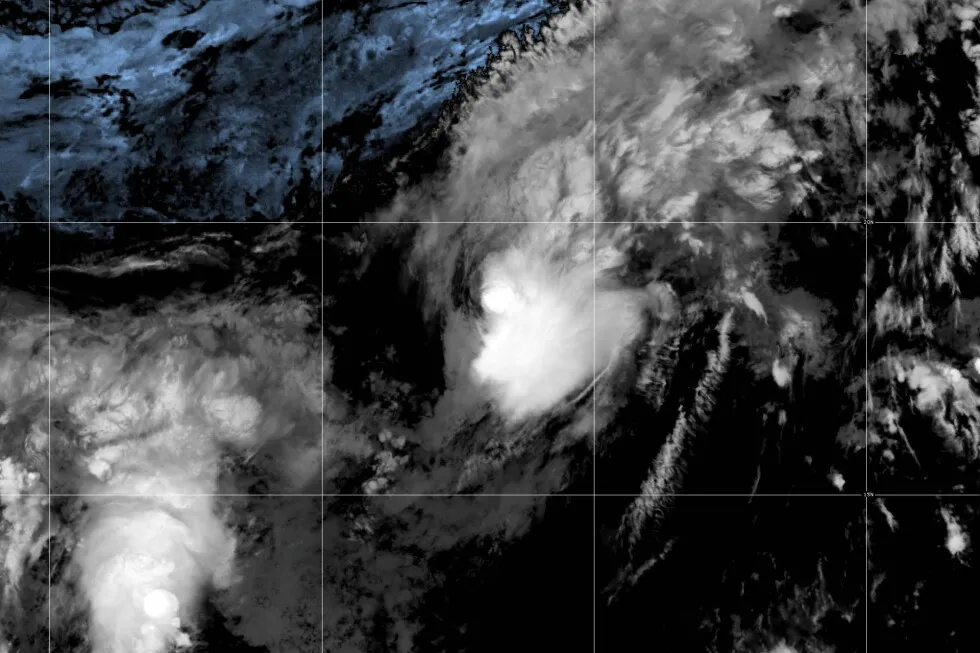
Tropical Storm Hernan forms in the Pacific while a different weather system could soak Hawaii 1 of 3 | This NOAA satellite image shows a tropical depression becoming Tropical Storm Hernan over the East Pacific, Thursday, Aug. 13, 2026. (NOAA via AP) 2 of 3 | This NOAA satellite image taken at 11:38 a.m. EST on Wednesday, Aug. 12, 2026, shows a Potential Tropical Cyclone One-C, about 1,000-miles east-southeast of the Hawaiian Islands. (NOAA via AP) 3 of 3 | This NOAA satellite image taken at 11:21 a.m. EST on Wednesday, Aug. 12, 2026, shows Tropical Storm Cristobal in the Atlantic Ocean. (NOAA via AP) 1 of 3 | This NOAA satellite image shows a tropical depression becoming Tropical Storm Hernan over the East Pacific, Thursday, Aug. 13, 2026. (NOAA via AP) 1 of 3 This NOAA satellite image shows a tropical depression becoming Tropical Storm Hernan over the East Pacific, Thursday, Aug. 13, 2026. (NOAA via AP) Add AP News on Google Add AP News as your preferred source to see more of our stories on Google. Share 2 of 3 | This NOAA satellite image taken at 11:38 a.m. EST on Wednesday, Aug. 12, 2026, shows a Potential Tropical Cyclone One-C, about 1,000-miles east-southeast of the Hawaiian Islands. (NOAA via AP) 2 of 3 This NOAA satellite image taken at 11:38 a.m. EST on Wednesday, Aug. 12, 2026, shows a Potential Tropical Cyclone One-C, about 1,000-miles east-southeast of the Hawaiian Islands. (NOAA via AP) Add AP News on Google Add AP News as your preferred source to see more of our stories on Google. Share 3 of 3 | This NOAA satellite image taken at 11:21 a.m. EST on Wednesday, Aug. 12, 2026, shows Tropical Storm Cristobal in the Atlantic Ocean. (NOAA via AP) 3 of 3 This NOAA satellite image taken at 11:21 a.m. EST on Wednesday, Aug. 12, 2026, shows Tropical Storm Cristobal in the Atlantic Ocean. (NOAA via AP) Add AP News on Google Add AP News as your preferred source to see more of our stories on Google. Share Updated [hour]:[minute] [AMPM] [timezone], [monthFull] [day], [year] HONOLULU (AP) — Tropical Storm Hernan formed Thursday in the Pacific Ocean and wasn’t threatening land while a different storm system that could bring heavy rain and flooding this weekend moved toward Hawaii, forecasters said.Hernan was about 1,460 miles (2,350 kilometers) west of the southern tip of the Baja California Peninsula of Mexico, the National Hurricane Center said. Maximum sustained winds were around 40 mph (64 kph) and it was moving west.Meanwhile, Potential Tropical Cyclone One-C was about 775 miles (1,247 kilometers) east-southeast of Hawaii and was forecast to bring heavy rain, high winds and dangerous surf to the Hawaiian Islands starting late Friday.Winds were around 40 mph, but it wasn’t organized enough to be considered a tropical storm, the Miami-based center said.It could make landfall on the southern part of the Big Island as a tropical storm on Saturday, forecasters said. The system could bring rainfall totals of 5 to 10 inches (13 to 25 centimeters) in the island chain, with up to 20 inches (51 centimeters) possible, forecasters said. That could produce flooding and mudslides, the center said.In the Atlantic Ocean, Tropical Storm Cristobal weakened into a tropical depression and was expected to dissipate Thursday, the center said. It was about 610 miles (982 kilometers) west of the Azores and didn’t threaten land.
SRCAssociated Press (AP)
LANGEN
LEANCenter
WORDS567
ENT10
THU · 2026-08-13 · 10:53 GMTBRIEF NSR-2026-0813-101917
NSR-2026-0813-101917News Report·EN·Environmental
Tropical Storm Hernan forms in the Pacific while a different weather system could soak Hawaii
Tropical Storm Hernan formed in the Pacific Ocean on Thursday, August 13, 2026, moving west with sustained winds of 40 mph and posing no threat to land. Meanwhile, a separate system, Potential Tropical Cyclone One-C, was approaching Hawaii and was forecast to bring heavy rain, high winds, and dangerous surf starting late Friday.
2 MIN READ
859Associated Press (AP)Filed 2026-08-13 · 10:53 GMTLean · CenterRead · 3 min
Associated Press (AP)FIG 01
Reading time
3min
Word count
567words
Sources cited
2cited
Entities identified
10entities
Quality score
100%
§ 01
Briefing Summary
AI-generatedNEWSAR · AI
Tropical Storm Hernan formed in the Pacific Ocean on Thursday, August 13, 2026, moving west with sustained winds of 40 mph and posing no threat to land. Meanwhile, a separate system, Potential Tropical Cyclone One-C, was approaching Hawaii and was forecast to bring heavy rain, high winds, and dangerous surf starting late Friday. This system could make landfall on the Big Island as a tropical storm on Saturday, with potential rainfall totals of 5 to 10 inches, and up to 20 inches in some areas, increasing the risk of flooding and mudslides. In the Atlantic, Tropical Storm Cristobal weakened into a tropical depression and was expected to dissipate on Thursday, also not threatening land.
Confidence 0.90Sources 2Claims 5Entities 10
§ 02
Article analysis
Model · rule-basedFraming
Environmental
Human Interest
Tone
Measured
AI-assessed
CalmNeutralAlarmist
Factuality
0.90 / 1.00
Factual
LowHigh
Sources cited
2
Limited
FewMany
§ 03
Key claims
5 extracted01
Potential Tropical Cyclone One-C was about 775 miles east-southeast of Hawaii.
factualNational Hurricane Center
Confidence
1.00
02
Tropical Storm Hernan formed in the Pacific Ocean.
factualNational Hurricane Center
Confidence
1.00
03
A different storm system, Potential Tropical Cyclone One-C, was moving toward Hawaii and could bring heavy rain and flooding.
predictionforecasters
Confidence
0.90
04
The system could bring rainfall totals of 5 to 10 inches to parts of Hawaii.
predictionforecasters
Confidence
0.80
05
Potential Tropical Cyclone One-C could make landfall on the southern part of the Big Island as a tropical storm on Saturday.
predictionforecasters
Confidence
0.80
§ 04
Full report
3 min read · 567 words§ 05
Entities
10 identifiedKey playerOppositionContextPositiveNeutralNegative
Organizations2
Locations5
§ 06
Keywords & salience
9 termstropical storm hernan
1.00
weather system
0.90
pacific ocean
0.80
hawaii
0.70
forecasters
0.60
flooding
0.50
heavy rain
0.50
national hurricane center
0.40
tropical cyclone
0.40
§ 07
Topic connections
Interactive graph No topic relationship data available yet. This graph will appear once topic relationships have been computed.