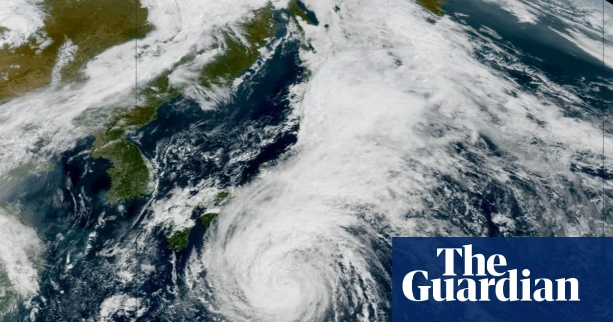
Tropical Storm Dujuan is skirting the coast of Japan and despite avoiding a direct landfall, is still expected to leave its mark. Dujuan briefly reached typhoon status on Friday before weakening to a tropical storm again on Sunday morning. But it is expected to restrengthen back to a typhoon by Tuesday morning. Sustained winds could reach 80mph (129km/h), with gusts approaching 100mph.Although mainland Japan has avoided a direct hit, Dujuan’s track takes it across the Izu Islands, where evacuation warnings are in place. Heavy rain, flooding and landslide alerts are widespread, with high waves adding another threat to exposed coastal areas and islands.Some exceptional rainfall totals are expected, with about 200mm (7.9in) possible along the southern coasts of the Chubu and Kanto regions in just 24 hours – roughly equivalent to the average rainfall for the entire month of September. The Tokyo metropolitan area is among the areas facing the heaviest rain, with some models suggesting nearly 90mm could fall within six hours on Monday evening. Further south, the Izu Peninsula could receive more than 80mm in just three hours – 38% of the month’s usual rainfall in a single evening. Dujuan is expected to continue north-eastwards before dissipating in the north-west Pacific later this week.The Atlantic hurricane season remains unusually quiet, despite Tropical Storm Fay developing south-west of the Azores over the weekend. Fay is not expected to strengthen further, extending the record for the latest first hurricane to form in a hurricane season during the satellite era. The previous date record was 11 September, set in 2002 with Hurricane Gustav and equalled in 2013 with Hurricane Humberto.South-west Europe may get one last taste of summer with a blast of heat this week. Temperatures across Spain and Portugal will rise significantly above the monthly norm, to the low to mid 30s celsius. Even in north-west Spain, in Santiago de Compostela highs could reach about 35C (95F) on Tuesday, about 12C above the typical daytime high. Heading into the weekend, warmth will spread into central Europe, but most likely with less intensity than earlier in the week across the Iberian peninsula.
SRCThe Guardian - World News
LANGEN
LEANCenter-Left
WORDS351
ENT12
MON · 2026-09-21 · 09:45 GMTBRIEF NSR-2026-0921-112866
NSR-2026-0921-112866News Report·EN·Human Interest
Weather tracker: Japanese islands brace for Dujuan to become a typhoon again
Tropical Storm Dujuan is expected to re-strengthen into a typhoon by Tuesday morning as it approaches Japan's Izu Islands. Sustained winds could reach 80 mph with gusts up to 100 mph.
Jodie Woodcock for MetDeskThe Guardian - World NewsFiled 2026-09-21 · 09:45 GMTLean · Center-LeftRead · 2 min
The Guardian - World NewsFIG 01
Reading time
2min
Word count
351words
Sources cited
0cited
Entities identified
12entities
Quality score
100%
§ 01
Briefing Summary
AI-generatedNEWSAR · AI
Tropical Storm Dujuan is expected to re-strengthen into a typhoon by Tuesday morning as it approaches Japan's Izu Islands. Sustained winds could reach 80 mph with gusts up to 100 mph. While mainland Japan has avoided a direct hit, the Izu Islands are under evacuation warnings due to anticipated heavy rain, flooding, landslides, and high waves. Significant rainfall is expected, with some areas potentially receiving a month's worth of September rain in just 24 hours. Meanwhile, the Atlantic hurricane season remains unusually quiet, with Tropical Storm Fay not expected to strengthen further, extending the record for the latest first hurricane formation.
Confidence 0.90Claims 4Entities 12
§ 02
Article analysis
Model · rule-basedFraming
Human Interest
Environmental
Tone
Mixed Tone
AI-assessed
CalmNeutralAlarmist
Factuality
0.80 / 1.00
Factual
LowHigh
Sources cited
0
No named sources
FewMany
§ 03
Key claims
4 extracted01
The Atlantic hurricane season remains unusually quiet, extending the record for the latest first hurricane to form in a hurricane season.
factual
Confidence
0.95
02
Exceptional rainfall totals are expected, with about 200mm possible along the southern coasts of the Chubu and Kanto regions in just 24 hours.
statistic
Confidence
0.90
03
Tropical Storm Dujuan is expected to restrengthen back to a typhoon by Tuesday morning with sustained winds potentially reaching 80mph.
prediction
Confidence
0.90
04
Temperatures across Spain and Portugal will rise significantly above the monthly norm, to the low to mid 30s celsius.
prediction
Confidence
0.85
§ 04
Full report
2 min read · 351 words§ 05
Entities
12 identifiedKey playerOppositionContextPositiveNeutralNegative
Locations10
§ 06
Keywords & salience
10 termstropical storm dujuan
1.00
typhoon
0.90
japan
0.80
heavy rain
0.70
flooding
0.60
landslide alerts
0.60
evacuation warnings
0.50
atlantic hurricane season
0.40
heatwave
0.40
spain
0.40
§ 07
Topic connections
Interactive graph Network visualization showing 11 related topics
View Full Graph Person Organization Location Event|Click node to navigate|Edge numbers = shared articles