This satellite image released by NOAA shows Hurricane Fausto, center, and Hurricane Genevieve off the southwest coast of Mexico, right, over the Pacific Ocean, Sunday, July 26, 2026. (NOAA via AP) 2026-07-27T09:01:02Z Miami (AP) — Genevieve became a Category 5 hurricane early Monday, the first in the East Pacific region in two years, forecasters said. It is expected to stay far out to sea on a course roughly parallel with the Mexico coast. Genevieve had maximum sustained winds of 160 mph (260 kph), according to the National Hurricane Center in Miami. Genevieve’s center was located about 530 miles (855 kilometers) southwest of Manzanillo, and it was headed northwest at 13 mph (20 kph). No coastal watches or warnings were in effect, but the hurricane center said that swells from the storm — likely causing “life-threatening surf and rip current conditions” — were affecting parts of Mexico’s southwestern coast and the Baja California Peninsula. The storm was expected to begin weakening from Tuesday. Farther northwest in the Pacific, Hurricane Fausto weakened to a Category 1 storm as it continued on a path in the general direction of the Hawaiian Islands. Forecasters said Fausto was expected to be downgraded to a tropical storm in the coming days but warned that it could still generate significant surf for parts of Hawaii. Fausto had maximum sustained winds of 80 mph (130 kph). It was located about 670 miles (1,080 kilometers) east of Hilo and was moving west-northwest at 14 mph (22 kph). 获取更多RSS: https://feedx.net https://feedx.site
SRCAssociated Press (AP)
LANGEN
LEANCenter
WORDS251
ENT12
MON · 2026-07-27 · 09:23 GMTBRIEF NSR-2026-0727-96353
NSR-2026-0727-96353News Report·EN·Environmental
Genevieve becomes a Category 5 hurricane but is not expected to make landfall
Hurricane Genevieve intensified into a Category 5 storm early Monday, the first in the East Pacific in two years, with maximum sustained winds of 160 mph. Forecasters state Genevieve is expected to remain far offshore, tracking northwest roughly parallel to the Mexican coast, and is predicted to weaken starting Tuesday.
Associated Press (AP)Filed 2026-07-27 · 09:23 GMTLean · CenterRead · 2 min
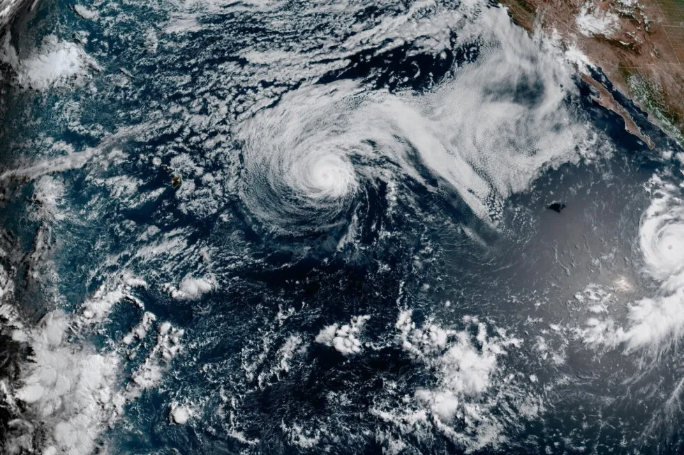
Associated Press (AP)FIG 01
Reading time
2min
Word count
251words
Sources cited
1cited
Entities identified
12entities
Quality score
100%
§ 01
Briefing Summary
AI-generatedNEWSAR · AI
Hurricane Genevieve intensified into a Category 5 storm early Monday, the first in the East Pacific in two years, with maximum sustained winds of 160 mph. Forecasters state Genevieve is expected to remain far offshore, tracking northwest roughly parallel to the Mexican coast, and is predicted to weaken starting Tuesday. While no coastal watches or warnings are active, swells from Genevieve are causing life-threatening surf and rip currents along parts of Mexico's southwestern coast and the Baja California Peninsula. Meanwhile, Hurricane Fausto, located further northwest, weakened to a Category 1 storm and is heading towards the Hawaiian Islands, though it is expected to become a tropical storm and could still generate significant surf.
Confidence 0.90Sources 1Claims 4Entities 12
§ 02
Article analysis
Model · rule-basedFraming
Environmental
Human Interest
Tone
Measured
AI-assessed
CalmNeutralAlarmist
Factuality
0.90 / 1.00
Factual
LowHigh
Sources cited
1
Limited
FewMany
§ 03
Key claims
4 extracted01
Genevieve had maximum sustained winds of 160 mph (260 kph).
statisticNational Hurricane Center
Confidence
1.00
02
Genevieve became a Category 5 hurricane early Monday, the first in the East Pacific region in two years.
factualforecasters
Confidence
1.00
03
Swells from the storm were affecting parts of Mexico’s southwestern coast and the Baja California Peninsula, likely causing life-threatening surf and rip current conditions.
factualhurricane center
Confidence
0.90
04
Hurricane Fausto weakened to a Category 1 storm and could still generate significant surf for parts of Hawaii.
predictionForecasters
Confidence
0.80
§ 04
Full report
2 min read · 251 words§ 05
Entities
12 identifiedKey playerOppositionContextPositiveNeutralNegative
Organizations3
Locations7
§ 06
Keywords & salience
10 termshurricane genevieve
1.00
category 5 hurricane
1.00
east pacific region
0.80
hurricane fausto
0.70
pacific ocean
0.60
mexico coast
0.60
tropical storm
0.50
national hurricane center
0.50
hawaiian islands
0.40
rip current conditions
0.40
§ 07
Topic connections
Interactive graph No topic relationship data available yet. This graph will appear once topic relationships have been computed.