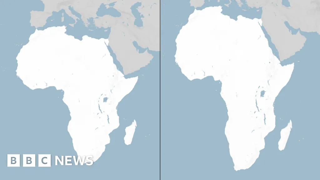
The UN General Assembly has voted to replace the traditional world map with one that more accurately reflects the size of Africa.The "Correct the Map" resolution, sponsored by Togo and backed by African Union (AU) members, passed with the support of 164 nations, including France and the UK. The United States was the only nation to vote against it - and there were six abstentions.The Mercator map, which has been in common use since the 16th Century, has come in for criticism as it shows Africa as similar in size to Greenland, even though it is 14 times larger.Critics say this leads to the development needs and potential for countries near the equator to be minimised.The Mercator map was designed in 1569 by the Flemish cartographer Gerardus Mercator to help European explorers navigate across the world.The distortion of his map is a result of the fact that it is impossible to accurately represent the surface of a globe on a two-dimensional chart.Whenever a map of the world is drawn, compromises need to be made.
SRCBBC News - World
LANGEN
LEANCenter
WORDS174
ENT10
FRI · 2026-09-04 · 17:26 GMTBRIEF NSR-2026-0904-109296
NSR-2026-0904-109296News Report·EN·Diplomatic
UN votes to adopt new world map to reflect Africa's true size
The UN General Assembly has voted to adopt a new world map that more accurately depicts Africa's size. This resolution, sponsored by Togo and supported by African Union members, passed with 164 nations voting in favor, while the United States was the sole nation to vote against it, with six abstentions.
49 minutes agoBBC News - WorldFiled 2026-09-04 · 17:26 GMTLean · CenterRead · 1 min
BBC News - WorldFIG 01
Reading time
1min
Word count
174words
Sources cited
0cited
Entities identified
10entities
Quality score
100%
§ 01
Briefing Summary
AI-generatedNEWSAR · AI
The UN General Assembly has voted to adopt a new world map that more accurately depicts Africa's size. This resolution, sponsored by Togo and supported by African Union members, passed with 164 nations voting in favor, while the United States was the sole nation to vote against it, with six abstentions. The change addresses criticisms of the traditional Mercator map, which has been in use since the 16th century and inaccurately portrays Africa as being similar in size to Greenland, despite being 14 times larger. Critics argue this distortion can minimize the development needs and potential of equatorial countries. The Mercator map's distortions are a result of the inherent challenge in representing a globe on a flat surface.
Confidence 0.90Claims 5Entities 10
§ 02
Article analysis
Model · rule-basedFraming
Diplomatic
Social Justice
Tone
Measured
AI-assessed
CalmNeutralAlarmist
Factuality
0.90 / 1.00
Factual
LowHigh
Sources cited
0
No named sources
FewMany
§ 03
Key claims
5 extracted01
The Mercator map was designed in 1569 by Gerardus Mercator to help European explorers navigate.
factual
Confidence
1.00
02
The Mercator map shows Africa as similar in size to Greenland, even though it is 14 times larger.
factual
Confidence
1.00
03
The United States was the only nation to vote against the resolution.
factual
Confidence
1.00
04
The 'Correct the Map' resolution passed with the support of 164 nations, including France and the UK.
factual
Confidence
1.00
05
The UN General Assembly voted to replace the traditional world map with one that more accurately reflects the size of Africa.
factual
Confidence
1.00
§ 04
Full report
1 min read · 174 words§ 05
Entities
10 identifiedKey playerOppositionContextPositiveNeutralNegative
Organizations2
Locations6
§ 06
Keywords & salience
9 termsworld map
1.00
africa size
1.00
mercator map
0.90
un general assembly
0.80
map distortion
0.70
cartography
0.70
geographical representation
0.60
african union
0.50
resolution
0.40
§ 07
Topic connections
Interactive graph Network visualization showing 21 related topics
View Full Graph Person Organization Location Event|Click node to navigate|Edge numbers = shared articles